Get trending papers in your email inbox once a day!
Get trending papers in your email inbox!
Subscribe


DeepAqua: Self-Supervised Semantic Segmentation of Wetlands from SAR Images using Knowledge Distillation
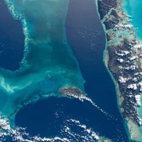
Remote sensing has significantly advanced water detection by applying semantic segmentation techniques to satellite imagery. However, semantic segmentation remains challenging due to the substantial amount of annotated data required. This is particularly problematic in wetland detection, where water extent varies over time and space, necessitating multiple annotations for the same area. In this paper, we present DeepAqua, a self-supervised deep learning model that leverages knowledge distillation to eliminate the need for manual annotations during the training phase. DeepAqua utilizes the Normalized Difference Water Index (NDWI) as a teacher model to train a Convolutional Neural Network (CNN) for segmenting water from Synthetic Aperture Radar (SAR) images. To train the student model, we exploit cases where optical- and radar-based water masks coincide, enabling the detection of both open and vegetated water surfaces. Our model represents a significant advancement in computer vision techniques by effectively training semantic segmentation models without any manually annotated data. This approach offers a practical solution for monitoring wetland water extent changes without needing ground truth data, making it highly adaptable and scalable for wetland conservation efforts.
Semantic Segmentation of Underwater Imagery: Dataset and Benchmark
In this paper, we present the first large-scale dataset for semantic Segmentation of Underwater IMagery (SUIM). It contains over 1500 images with pixel annotations for eight object categories: fish (vertebrates), reefs (invertebrates), aquatic plants, wrecks/ruins, human divers, robots, and sea-floor. The images have been rigorously collected during oceanic explorations and human-robot collaborative experiments, and annotated by human participants. We also present a benchmark evaluation of state-of-the-art semantic segmentation approaches based on standard performance metrics. In addition, we present SUIM-Net, a fully-convolutional encoder-decoder model that balances the trade-off between performance and computational efficiency. It offers competitive performance while ensuring fast end-to-end inference, which is essential for its use in the autonomy pipeline of visually-guided underwater robots. In particular, we demonstrate its usability benefits for visual servoing, saliency prediction, and detailed scene understanding. With a variety of use cases, the proposed model and benchmark dataset open up promising opportunities for future research in underwater robot vision.
LaRS: A Diverse Panoptic Maritime Obstacle Detection Dataset and Benchmark
The progress in maritime obstacle detection is hindered by the lack of a diverse dataset that adequately captures the complexity of general maritime environments. We present the first maritime panoptic obstacle detection benchmark LaRS, featuring scenes from Lakes, Rivers and Seas. Our major contribution is the new dataset, which boasts the largest diversity in recording locations, scene types, obstacle classes, and acquisition conditions among the related datasets. LaRS is composed of over 4000 per-pixel labeled key frames with nine preceding frames to allow utilization of the temporal texture, amounting to over 40k frames. Each key frame is annotated with 8 thing, 3 stuff classes and 19 global scene attributes. We report the results of 27 semantic and panoptic segmentation methods, along with several performance insights and future research directions. To enable objective evaluation, we have implemented an online evaluation server. The LaRS dataset, evaluation toolkit and benchmark are publicly available at: https://lojzezust.github.io/lars-dataset
Attention Neural Network for Trash Detection on Water Channels
Rivers and canals flowing through cities are often used illegally for dumping the trash. This contaminates freshwater channels as well as causes blockage in sewerage resulting in urban flooding. When this contaminated water reaches agricultural fields, it results in degradation of soil and poses critical environmental as well as economic threats. The dumped trash is often found floating on the water surface. The trash could be disfigured, partially submerged, decomposed into smaller pieces, clumped together with other objects which obscure its shape and creates a challenging detection problem. This paper proposes a method for the detection of visible trash floating on the water surface of the canals in urban areas. We also provide a large dataset, first of its kind, trash in water channels that contains object-level annotations. A novel attention layer is proposed that improves the detection of smaller objects. Towards the end of this paper, we provide a detailed comparison of our method with state-of-the-art object detectors and show that our method significantly improves the detection of smaller objects. The dataset will be made publicly available.

The Coralscapes Dataset: Semantic Scene Understanding in Coral Reefs
Coral reefs are declining worldwide due to climate change and local stressors. To inform effective conservation or restoration, monitoring at the highest possible spatial and temporal resolution is necessary. Conventional coral reef surveying methods are limited in scalability due to their reliance on expert labor time, motivating the use of computer vision tools to automate the identification and abundance estimation of live corals from images. However, the design and evaluation of such tools has been impeded by the lack of large high quality datasets. We release the Coralscapes dataset, the first general-purpose dense semantic segmentation dataset for coral reefs, covering 2075 images, 39 benthic classes, and 174k segmentation masks annotated by experts. Coralscapes has a similar scope and the same structure as the widely used Cityscapes dataset for urban scene segmentation, allowing benchmarking of semantic segmentation models in a new challenging domain which requires expert knowledge to annotate. We benchmark a wide range of semantic segmentation models, and find that transfer learning from Coralscapes to existing smaller datasets consistently leads to state-of-the-art performance. Coralscapes will catalyze research on efficient, scalable, and standardized coral reef surveying methods based on computer vision, and holds the potential to streamline the development of underwater ecological robotics.
Image Labels Are All You Need for Coarse Seagrass Segmentation
Seagrass meadows serve as critical carbon sinks, but accurately estimating the amount of carbon they store requires knowledge of the seagrass species present. Using underwater and surface vehicles equipped with machine learning algorithms can help to accurately estimate the composition and extent of seagrass meadows at scale. However, previous approaches for seagrass detection and classification have required full supervision from patch-level labels. In this paper, we reframe seagrass classification as a weakly supervised coarse segmentation problem where image-level labels are used during training (25 times fewer labels compared to patch-level labeling) and patch-level outputs are obtained at inference time. To this end, we introduce SeaFeats, an architecture that uses unsupervised contrastive pretraining and feature similarity to separate background and seagrass patches, and SeaCLIP, a model that showcases the effectiveness of large language models as a supervisory signal in domain-specific applications. We demonstrate that an ensemble of SeaFeats and SeaCLIP leads to highly robust performance, with SeaCLIP conservatively predicting the background class to avoid false seagrass misclassifications in blurry or dark patches. Our method outperforms previous approaches that require patch-level labels on the multi-species 'DeepSeagrass' dataset by 6.8% (absolute) for the class-weighted F1 score, and by 12.1% (absolute) F1 score for seagrass presence/absence on the 'Global Wetlands' dataset. We also present two case studies for real-world deployment: outlier detection on the Global Wetlands dataset, and application of our method on imagery collected by FloatyBoat, an autonomous surface vehicle.
AutoFish: Dataset and Benchmark for Fine-grained Analysis of Fish
Automated fish documentation processes are in the near future expected to play an essential role in sustainable fisheries management and for addressing challenges of overfishing. In this paper, we present a novel and publicly available dataset named AutoFish designed for fine-grained fish analysis. The dataset comprises 1,500 images of 454 specimens of visually similar fish placed in various constellations on a white conveyor belt and annotated with instance segmentation masks, IDs, and length measurements. The data was collected in a controlled environment using an RGB camera. The annotation procedure involved manual point annotations, initial segmentation masks proposed by the Segment Anything Model (SAM), and subsequent manual correction of the masks. We establish baseline instance segmentation results using two variations of the Mask2Former architecture, with the best performing model reaching an mAP of 89.15%. Additionally, we present two baseline length estimation methods, the best performing being a custom MobileNetV2-based regression model reaching an MAE of 0.62cm in images with no occlusion and 1.38cm in images with occlusion. Link to project page: https://vap.aau.dk/autofish/.
The Common Objects Underwater (COU) Dataset for Robust Underwater Object Detection
We introduce COU: Common Objects Underwater, an instance-segmented image dataset of commonly found man-made objects in multiple aquatic and marine environments. COU contains approximately 10K segmented images, annotated from images collected during a number of underwater robot field trials in diverse locations. COU has been created to address the lack of datasets with robust class coverage curated for underwater instance segmentation, which is particularly useful for training light-weight, real-time capable detectors for Autonomous Underwater Vehicles (AUVs). In addition, COU addresses the lack of diversity in object classes since the commonly available underwater image datasets focus only on marine life. Currently, COU contains images from both closed-water (pool) and open-water (lakes and oceans) environments, of 24 different classes of objects including marine debris, dive tools, and AUVs. To assess the efficacy of COU in training underwater object detectors, we use three state-of-the-art models to evaluate its performance and accuracy, using a combination of standard accuracy and efficiency metrics. The improved performance of COU-trained detectors over those solely trained on terrestrial data demonstrates the clear advantage of training with annotated underwater images. We make COU available for broad use under open-source licenses.
SegEarth-OV: Towards Traning-Free Open-Vocabulary Segmentation for Remote Sensing Images
Remote sensing image plays an irreplaceable role in fields such as agriculture, water resources, military, and disaster relief. Pixel-level interpretation is a critical aspect of remote sensing image applications; however, a prevalent limitation remains the need for extensive manual annotation. For this, we try to introduce open-vocabulary semantic segmentation (OVSS) into the remote sensing context. However, due to the sensitivity of remote sensing images to low-resolution features, distorted target shapes and ill-fitting boundaries are exhibited in the prediction mask. To tackle this issue, we propose a simple and general upsampler, SimFeatUp, to restore lost spatial information in deep features in a training-free style. Further, based on the observation of the abnormal response of local patch tokens to [CLS] token in CLIP, we propose to execute a straightforward subtraction operation to alleviate the global bias in patch tokens. Extensive experiments are conducted on 17 remote sensing datasets spanning semantic segmentation, building extraction, road detection, and flood detection tasks. Our method achieves an average of 5.8%, 8.2%, 4%, and 15.3% improvement over state-of-the-art methods on 4 tasks. All codes are released. https://earth-insights.github.io/SegEarth-OV

CutS3D: Cutting Semantics in 3D for 2D Unsupervised Instance Segmentation
Traditionally, algorithms that learn to segment object instances in 2D images have heavily relied on large amounts of human-annotated data. Only recently, novel approaches have emerged tackling this problem in an unsupervised fashion. Generally, these approaches first generate pseudo-masks and then train a class-agnostic detector. While such methods deliver the current state of the art, they often fail to correctly separate instances overlapping in 2D image space since only semantics are considered. To tackle this issue, we instead propose to cut the semantic masks in 3D to obtain the final 2D instances by utilizing a point cloud representation of the scene. Furthermore, we derive a Spatial Importance function, which we use to resharpen the semantics along the 3D borders of instances. Nevertheless, these pseudo-masks are still subject to mask ambiguity. To address this issue, we further propose to augment the training of a class-agnostic detector with three Spatial Confidence components aiming to isolate a clean learning signal. With these contributions, our approach outperforms competing methods across multiple standard benchmarks for unsupervised instance segmentation and object detection.


LISAT: Language-Instructed Segmentation Assistant for Satellite Imagery
Segmentation models can recognize a pre-defined set of objects in images. However, models that can reason over complex user queries that implicitly refer to multiple objects of interest are still in their infancy. Recent advances in reasoning segmentation--generating segmentation masks from complex, implicit query text--demonstrate that vision-language models can operate across an open domain and produce reasonable outputs. However, our experiments show that such models struggle with complex remote-sensing imagery. In this work, we introduce LISAt, a vision-language model designed to describe complex remote-sensing scenes, answer questions about them, and segment objects of interest. We trained LISAt on a new curated geospatial reasoning-segmentation dataset, GRES, with 27,615 annotations over 9,205 images, and a multimodal pretraining dataset, PreGRES, containing over 1 million question-answer pairs. LISAt outperforms existing geospatial foundation models such as RS-GPT4V by over 10.04 % (BLEU-4) on remote-sensing description tasks, and surpasses state-of-the-art open-domain models on reasoning segmentation tasks by 143.36 % (gIoU). Our model, datasets, and code are available at https://lisat-bair.github.io/LISAt/


ReferEverything: Towards Segmenting Everything We Can Speak of in Videos
We present REM, a framework for segmenting a wide range of concepts in video that can be described through natural language. Our method capitalizes on visual-language representations learned by video diffusion models on Internet-scale datasets. A key insight of our approach is preserving as much of the generative model's original representation as possible, while fine-tuning it on narrow-domain Referral Object Segmentation datasets. As a result, our framework can accurately segment and track rare and unseen objects, despite being trained on object masks from a limited set of categories. Additionally, it can generalize to non-object dynamic concepts, such as waves crashing in the ocean, as demonstrated in our newly introduced benchmark for Referral Video Process Segmentation (Ref-VPS). Our experiments show that REM performs on par with state-of-the-art approaches on in-domain datasets, like Ref-DAVIS, while outperforming them by up to twelve points in terms of region similarity on out-of-domain data, leveraging the power of Internet-scale pre-training.


Delineate Anything: Resolution-Agnostic Field Boundary Delineation on Satellite Imagery
The accurate delineation of agricultural field boundaries from satellite imagery is vital for land management and crop monitoring. However, current methods face challenges due to limited dataset sizes, resolution discrepancies, and diverse environmental conditions. We address this by reformulating the task as instance segmentation and introducing the Field Boundary Instance Segmentation - 22M dataset (FBIS-22M), a large-scale, multi-resolution dataset comprising 672,909 high-resolution satellite image patches (ranging from 0.25 m to 10 m) and 22,926,427 instance masks of individual fields, significantly narrowing the gap between agricultural datasets and those in other computer vision domains. We further propose Delineate Anything, an instance segmentation model trained on our new FBIS-22M dataset. Our proposed model sets a new state-of-the-art, achieving a substantial improvement of 88.5% in [email protected] and 103% in [email protected]:0.95 over existing methods, while also demonstrating significantly faster inference and strong zero-shot generalization across diverse image resolutions and unseen geographic regions. Code, pre-trained models, and the FBIS-22M dataset are available at https://lavreniuk.github.io/Delineate-Anything.

Improving extreme weather events detection with light-weight neural networks
To advance automated detection of extreme weather events, which are increasing in frequency and intensity with climate change, we explore modifications to a novel light-weight Context Guided convolutional neural network architecture trained for semantic segmentation of tropical cyclones and atmospheric rivers in climate data. Our primary focus is on tropical cyclones, the most destructive weather events, for which current models show limited performance. We investigate feature engineering, data augmentation, learning rate modifications, alternative loss functions, and architectural changes. In contrast to previous approaches optimizing for intersection over union, we specifically seek to improve recall to penalize under-counting and prioritize identification of tropical cyclones. We report success through the use of weighted loss functions to counter class imbalance for these rare events. We conclude with directions for future research on extreme weather events detection, a crucial task for prediction, mitigation, and equitable adaptation to the impacts of climate change.

Attention on the Sphere
We introduce a generalized attention mechanism for spherical domains, enabling Transformer architectures to natively process data defined on the two-dimensional sphere - a critical need in fields such as atmospheric physics, cosmology, and robotics, where preserving spherical symmetries and topology is essential for physical accuracy. By integrating numerical quadrature weights into the attention mechanism, we obtain a geometrically faithful spherical attention that is approximately rotationally equivariant, providing strong inductive biases and leading to better performance than Cartesian approaches. To further enhance both scalability and model performance, we propose neighborhood attention on the sphere, which confines interactions to geodesic neighborhoods. This approach reduces computational complexity and introduces the additional inductive bias for locality, while retaining the symmetry properties of our method. We provide optimized CUDA kernels and memory-efficient implementations to ensure practical applicability. The method is validated on three diverse tasks: simulating shallow water equations on the rotating sphere, spherical image segmentation, and spherical depth estimation. Across all tasks, our spherical Transformers consistently outperform their planar counterparts, highlighting the advantage of geometric priors for learning on spherical domains.
Residual Pattern Learning for Pixel-wise Out-of-Distribution Detection in Semantic Segmentation
Semantic segmentation models classify pixels into a set of known (``in-distribution'') visual classes. When deployed in an open world, the reliability of these models depends on their ability not only to classify in-distribution pixels but also to detect out-of-distribution (OoD) pixels. Historically, the poor OoD detection performance of these models has motivated the design of methods based on model re-training using synthetic training images that include OoD visual objects. Although successful, these re-trained methods have two issues: 1) their in-distribution segmentation accuracy may drop during re-training, and 2) their OoD detection accuracy does not generalise well to new contexts (e.g., country surroundings) outside the training set (e.g., city surroundings). In this paper, we mitigate these issues with: (i) a new residual pattern learning (RPL) module that assists the segmentation model to detect OoD pixels without affecting the inlier segmentation performance; and (ii) a novel context-robust contrastive learning (CoroCL) that enforces RPL to robustly detect OoD pixels among various contexts. Our approach improves by around 10\% FPR and 7\% AuPRC the previous state-of-the-art in Fishyscapes, Segment-Me-If-You-Can, and RoadAnomaly datasets. Our code is available at: https://github.com/yyliu01/RPL.
Segment3D: Learning Fine-Grained Class-Agnostic 3D Segmentation without Manual Labels
Current 3D scene segmentation methods are heavily dependent on manually annotated 3D training datasets. Such manual annotations are labor-intensive, and often lack fine-grained details. Importantly, models trained on this data typically struggle to recognize object classes beyond the annotated classes, i.e., they do not generalize well to unseen domains and require additional domain-specific annotations. In contrast, 2D foundation models demonstrate strong generalization and impressive zero-shot abilities, inspiring us to incorporate these characteristics from 2D models into 3D models. Therefore, we explore the use of image segmentation foundation models to automatically generate training labels for 3D segmentation. We propose Segment3D, a method for class-agnostic 3D scene segmentation that produces high-quality 3D segmentation masks. It improves over existing 3D segmentation models (especially on fine-grained masks), and enables easily adding new training data to further boost the segmentation performance -- all without the need for manual training labels.


Image-level Regression for Uncertainty-aware Retinal Image Segmentation
Accurate retinal vessel (RV) segmentation is a crucial step in the quantitative assessment of retinal vasculature, which is needed for the early detection of retinal diseases and other conditions. Numerous studies have been conducted to tackle the problem of segmenting vessels automatically using a pixel-wise classification approach. The common practice of creating ground truth labels is to categorize pixels as foreground and background. This approach is, however, biased, and it ignores the uncertainty of a human annotator when it comes to annotating e.g. thin vessels. In this work, we propose a simple and effective method that casts the RV segmentation task as an image-level regression. For this purpose, we first introduce a novel Segmentation Annotation Uncertainty-Aware (SAUNA) transform, which adds pixel uncertainty to the ground truth using the pixel's closeness to the annotation boundary and vessel thickness. To train our model with soft labels, we generalize the earlier proposed Jaccard metric loss to arbitrary hypercubes for soft Jaccard index (Intersection-over-Union) optimization. Additionally, we employ a stable version of the Focal-L1 loss for pixel-wise regression. We conduct thorough experiments and compare our method to a diverse set of baselines across 5 retinal image datasets. Our empirical results indicate that the integration of the SAUNA transform and these segmentation losses led to significant performance boosts for different segmentation models. Particularly, our methodology enables UNet-like architectures to substantially outperform computational-intensive baselines. Our implementation is available at https://github.com/Oulu-IMEDS/SAUNA.

SATR: Zero-Shot Semantic Segmentation of 3D Shapes
We explore the task of zero-shot semantic segmentation of 3D shapes by using large-scale off-the-shelf 2D image recognition models. Surprisingly, we find that modern zero-shot 2D object detectors are better suited for this task than contemporary text/image similarity predictors or even zero-shot 2D segmentation networks. Our key finding is that it is possible to extract accurate 3D segmentation maps from multi-view bounding box predictions by using the topological properties of the underlying surface. For this, we develop the Segmentation Assignment with Topological Reweighting (SATR) algorithm and evaluate it on ShapeNetPart and our proposed FAUST benchmarks. SATR achieves state-of-the-art performance and outperforms a baseline algorithm by 1.3% and 4% average mIoU on the FAUST coarse and fine-grained benchmarks, respectively, and by 5.2% average mIoU on the ShapeNetPart benchmark. Our source code and data will be publicly released. Project webpage: https://samir55.github.io/SATR/.

Spatially Guiding Unsupervised Semantic Segmentation Through Depth-Informed Feature Distillation and Sampling
Traditionally, training neural networks to perform semantic segmentation required expensive human-made annotations. But more recently, advances in the field of unsupervised learning have made significant progress on this issue and towards closing the gap to supervised algorithms. To achieve this, semantic knowledge is distilled by learning to correlate randomly sampled features from images across an entire dataset. In this work, we build upon these advances by incorporating information about the structure of the scene into the training process through the use of depth information. We achieve this by (1) learning depth-feature correlation by spatially correlate the feature maps with the depth maps to induce knowledge about the structure of the scene and (2) implementing farthest-point sampling to more effectively select relevant features by utilizing 3D sampling techniques on depth information of the scene. Finally, we demonstrate the effectiveness of our technical contributions through extensive experimentation and present significant improvements in performance across multiple benchmark datasets.

COSNet: A Novel Semantic Segmentation Network using Enhanced Boundaries in Cluttered Scenes
Automated waste recycling aims to efficiently separate the recyclable objects from the waste by employing vision-based systems. However, the presence of varying shaped objects having different material types makes it a challenging problem, especially in cluttered environments. Existing segmentation methods perform reasonably on many semantic segmentation datasets by employing multi-contextual representations, however, their performance is degraded when utilized for waste object segmentation in cluttered scenarios. In addition, plastic objects further increase the complexity of the problem due to their translucent nature. To address these limitations, we introduce an efficacious segmentation network, named COSNet, that uses boundary cues along with multi-contextual information to accurately segment the objects in cluttered scenes. COSNet introduces novel components including feature sharpening block (FSB) and boundary enhancement module (BEM) for enhancing the features and highlighting the boundary information of irregular waste objects in cluttered environment. Extensive experiments on three challenging datasets including ZeroWaste-f, SpectralWaste, and ADE20K demonstrate the effectiveness of the proposed method. Our COSNet achieves a significant gain of 1.8% on ZeroWaste-f and 2.1% on SpectralWaste datasets respectively in terms of mIoU metric.
Multi-Object Discovery by Low-Dimensional Object Motion
Recent work in unsupervised multi-object segmentation shows impressive results by predicting motion from a single image despite the inherent ambiguity in predicting motion without the next image. On the other hand, the set of possible motions for an image can be constrained to a low-dimensional space by considering the scene structure and moving objects in it. We propose to model pixel-wise geometry and object motion to remove ambiguity in reconstructing flow from a single image. Specifically, we divide the image into coherently moving regions and use depth to construct flow bases that best explain the observed flow in each region. We achieve state-of-the-art results in unsupervised multi-object segmentation on synthetic and real-world datasets by modeling the scene structure and object motion. Our evaluation of the predicted depth maps shows reliable performance in monocular depth estimation.
GeoGround: A Unified Large Vision-Language Model. for Remote Sensing Visual Grounding
Remote sensing (RS) visual grounding aims to use natural language expression to locate specific objects (in the form of the bounding box or segmentation mask) in RS images, enhancing human interaction with intelligent RS interpretation systems. Early research in this area was primarily based on horizontal bounding boxes (HBBs), but as more diverse RS datasets have become available, tasks involving oriented bounding boxes (OBBs) and segmentation masks have emerged. In practical applications, different targets require different grounding types: HBB can localize an object's position, OBB provides its orientation, and mask depicts its shape. However, existing specialized methods are typically tailored to a single type of RS visual grounding task and are hard to generalize across tasks. In contrast, large vision-language models (VLMs) exhibit powerful multi-task learning capabilities but struggle to handle dense prediction tasks like segmentation. This paper proposes GeoGround, a novel framework that unifies support for HBB, OBB, and mask RS visual grounding tasks, allowing flexible output selection. Rather than customizing the architecture of VLM, our work aims to elegantly support pixel-level visual grounding output through the Text-Mask technique. We define prompt-assisted and geometry-guided learning to enhance consistency across different signals. To support model training, we present refGeo, a large-scale RS visual instruction-following dataset containing 161k image-text pairs. Experimental results show that GeoGround demonstrates strong performance across four RS visual grounding tasks, matching or surpassing the performance of specialized methods on multiple benchmarks. Code available at https://github.com/zytx121/GeoGround
P2Seg: Pointly-supervised Segmentation via Mutual Distillation
Point-level Supervised Instance Segmentation (PSIS) aims to enhance the applicability and scalability of instance segmentation by utilizing low-cost yet instance-informative annotations. Existing PSIS methods usually rely on positional information to distinguish objects, but predicting precise boundaries remains challenging due to the lack of contour annotations. Nevertheless, weakly supervised semantic segmentation methods are proficient in utilizing intra-class feature consistency to capture the boundary contours of the same semantic regions. In this paper, we design a Mutual Distillation Module (MDM) to leverage the complementary strengths of both instance position and semantic information and achieve accurate instance-level object perception. The MDM consists of Semantic to Instance (S2I) and Instance to Semantic (I2S). S2I is guided by the precise boundaries of semantic regions to learn the association between annotated points and instance contours. I2S leverages discriminative relationships between instances to facilitate the differentiation of various objects within the semantic map. Extensive experiments substantiate the efficacy of MDM in fostering the synergy between instance and semantic information, consequently improving the quality of instance-level object representations. Our method achieves 55.7 mAP_{50} and 17.6 mAP on the PASCAL VOC and MS COCO datasets, significantly outperforming recent PSIS methods and several box-supervised instance segmentation competitors.

SegEarth-R1: Geospatial Pixel Reasoning via Large Language Model
Remote sensing has become critical for understanding environmental dynamics, urban planning, and disaster management. However, traditional remote sensing workflows often rely on explicit segmentation or detection methods, which struggle to handle complex, implicit queries that require reasoning over spatial context, domain knowledge, and implicit user intent. Motivated by this, we introduce a new task, \ie, geospatial pixel reasoning, which allows implicit querying and reasoning and generates the mask of the target region. To advance this task, we construct and release the first large-scale benchmark dataset called EarthReason, which comprises 5,434 manually annotated image masks with over 30,000 implicit question-answer pairs. Moreover, we propose SegEarth-R1, a simple yet effective language-guided segmentation baseline that integrates a hierarchical visual encoder, a large language model (LLM) for instruction parsing, and a tailored mask generator for spatial correlation. The design of SegEarth-R1 incorporates domain-specific adaptations, including aggressive visual token compression to handle ultra-high-resolution remote sensing images, a description projection module to fuse language and multi-scale features, and a streamlined mask prediction pipeline that directly queries description embeddings. Extensive experiments demonstrate that SegEarth-R1 achieves state-of-the-art performance on both reasoning and referring segmentation tasks, significantly outperforming traditional and LLM-based segmentation methods. Our data and code will be released at https://github.com/earth-insights/SegEarth-R1.
The revenge of BiSeNet: Efficient Multi-Task Image Segmentation
Recent advancements in image segmentation have focused on enhancing the efficiency of the models to meet the demands of real-time applications, especially on edge devices. However, existing research has primarily concentrated on single-task settings, especially on semantic segmentation, leading to redundant efforts and specialized architectures for different tasks. To address this limitation, we propose a novel architecture for efficient multi-task image segmentation, capable of handling various segmentation tasks without sacrificing efficiency or accuracy. We introduce BiSeNetFormer, that leverages the efficiency of two-stream semantic segmentation architectures and it extends them into a mask classification framework. Our approach maintains the efficient spatial and context paths to capture detailed and semantic information, respectively, while leveraging an efficient transformed-based segmentation head that computes the binary masks and class probabilities. By seamlessly supporting multiple tasks, namely semantic and panoptic segmentation, BiSeNetFormer offers a versatile solution for multi-task segmentation. We evaluate our approach on popular datasets, Cityscapes and ADE20K, demonstrating impressive inference speeds while maintaining competitive accuracy compared to state-of-the-art architectures. Our results indicate that BiSeNetFormer represents a significant advancement towards fast, efficient, and multi-task segmentation networks, bridging the gap between model efficiency and task adaptability.

Confidence-Weighted Boundary-Aware Learning for Semi-Supervised Semantic Segmentation
Semi-supervised semantic segmentation (SSSS) aims to improve segmentation performance by utilising unlabeled data alongside limited labeled samples. Existing SSSS methods often face challenges such as coupling, where over-reliance on initial labeled data leads to suboptimal learning; confirmation bias, where incorrect predictions reinforce themselves repeatedly; and boundary blur caused by insufficient boundary-awareness and ambiguous edge information. To address these issues, we propose CW-BASS, a novel framework for SSSS. In order to mitigate the impact of incorrect predictions, we assign confidence weights to pseudo-labels. Additionally, we leverage boundary-delineation techniques, which, despite being extensively explored in weakly-supervised semantic segmentation (WSSS) remain under-explored in SSSS. Specifically, our approach: (1) reduces coupling through a confidence-weighted loss function that adjusts the influence of pseudo-labels based on their predicted confidence scores, (2) mitigates confirmation bias with a dynamic thresholding mechanism that learns to filter out pseudo-labels based on model performance, (3) resolves boundary blur with a boundary-aware module that enhances segmentation accuracy near object boundaries, and (4) reduces label noise with a confidence decay strategy that progressively refines pseudo-labels during training. Extensive experiments on the Pascal VOC 2012 and Cityscapes demonstrate that our method achieves state-of-the-art performance. Moreover, using only 1/8 or 12.5\% of labeled data, our method achieves a mIoU of 75.81 on Pascal VOC 2012, highlighting its effectiveness in limited-label settings.

CloudTracks: A Dataset for Localizing Ship Tracks in Satellite Images of Clouds
Clouds play a significant role in global temperature regulation through their effect on planetary albedo. Anthropogenic emissions of aerosols can alter the albedo of clouds, but the extent of this effect, and its consequent impact on temperature change, remains uncertain. Human-induced clouds caused by ship aerosol emissions, commonly referred to as ship tracks, provide visible manifestations of this effect distinct from adjacent cloud regions and therefore serve as a useful sandbox to study human-induced clouds. However, the lack of large-scale ship track data makes it difficult to deduce their general effects on cloud formation. Towards developing automated approaches to localize ship tracks at scale, we present CloudTracks, a dataset containing 3,560 satellite images labeled with more than 12,000 ship track instance annotations. We train semantic segmentation and instance segmentation model baselines on our dataset and find that our best model substantially outperforms previous state-of-the-art for ship track localization (61.29 vs. 48.65 IoU). We also find that the best instance segmentation model is able to identify the number of ship tracks in each image more accurately than the previous state-of-the-art (1.64 vs. 4.99 MAE). However, we identify cases where the best model struggles to accurately localize and count ship tracks, so we believe CloudTracks will stimulate novel machine learning approaches to better detect elongated and overlapping features in satellite images. We release our dataset openly at {zenodo.org/records/10042922}.


FloodNet: A High Resolution Aerial Imagery Dataset for Post Flood Scene Understanding
Visual scene understanding is the core task in making any crucial decision in any computer vision system. Although popular computer vision datasets like Cityscapes, MS-COCO, PASCAL provide good benchmarks for several tasks (e.g. image classification, segmentation, object detection), these datasets are hardly suitable for post disaster damage assessments. On the other hand, existing natural disaster datasets include mainly satellite imagery which have low spatial resolution and a high revisit period. Therefore, they do not have a scope to provide quick and efficient damage assessment tasks. Unmanned Aerial Vehicle(UAV) can effortlessly access difficult places during any disaster and collect high resolution imagery that is required for aforementioned tasks of computer vision. To address these issues we present a high resolution UAV imagery, FloodNet, captured after the hurricane Harvey. This dataset demonstrates the post flooded damages of the affected areas. The images are labeled pixel-wise for semantic segmentation task and questions are produced for the task of visual question answering. FloodNet poses several challenges including detection of flooded roads and buildings and distinguishing between natural water and flooded water. With the advancement of deep learning algorithms, we can analyze the impact of any disaster which can make a precise understanding of the affected areas. In this paper, we compare and contrast the performances of baseline methods for image classification, semantic segmentation, and visual question answering on our dataset.

UrbanSAM: Learning Invariance-Inspired Adapters for Segment Anything Models in Urban Construction
Object extraction and segmentation from remote sensing (RS) images is a critical yet challenging task in urban environment monitoring. Urban morphology is inherently complex, with irregular objects of diverse shapes and varying scales. These challenges are amplified by heterogeneity and scale disparities across RS data sources, including sensors, platforms, and modalities, making accurate object segmentation particularly demanding. While the Segment Anything Model (SAM) has shown significant potential in segmenting complex scenes, its performance in handling form-varying objects remains limited due to manual-interactive prompting. To this end, we propose UrbanSAM, a customized version of SAM specifically designed to analyze complex urban environments while tackling scaling effects from remotely sensed observations. Inspired by multi-resolution analysis (MRA) theory, UrbanSAM incorporates a novel learnable prompter equipped with a Uscaling-Adapter that adheres to the invariance criterion, enabling the model to capture multiscale contextual information of objects and adapt to arbitrary scale variations with theoretical guarantees. Furthermore, features from the Uscaling-Adapter and the trunk encoder are aligned through a masked cross-attention operation, allowing the trunk encoder to inherit the adapter's multiscale aggregation capability. This synergy enhances the segmentation performance, resulting in more powerful and accurate outputs, supported by the learned adapter. Extensive experimental results demonstrate the flexibility and superior segmentation performance of the proposed UrbanSAM on a global-scale dataset, encompassing scale-varying urban objects such as buildings, roads, and water.
IAM: Enhancing RGB-D Instance Segmentation with New Benchmarks
Image segmentation is a vital task for providing human assistance and enhancing autonomy in our daily lives. In particular, RGB-D segmentation-leveraging both visual and depth cues-has attracted increasing attention as it promises richer scene understanding than RGB-only methods. However, most existing efforts have primarily focused on semantic segmentation and thus leave a critical gap. There is a relative scarcity of instance-level RGB-D segmentation datasets, which restricts current methods to broad category distinctions rather than fully capturing the fine-grained details required for recognizing individual objects. To bridge this gap, we introduce three RGB-D instance segmentation benchmarks, distinguished at the instance level. These datasets are versatile, supporting a wide range of applications from indoor navigation to robotic manipulation. In addition, we present an extensive evaluation of various baseline models on these benchmarks. This comprehensive analysis identifies both their strengths and shortcomings, guiding future work toward more robust, generalizable solutions. Finally, we propose a simple yet effective method for RGB-D data integration. Extensive evaluations affirm the effectiveness of our approach, offering a robust framework for advancing toward more nuanced scene understanding.
GAMUS: A Geometry-aware Multi-modal Semantic Segmentation Benchmark for Remote Sensing Data
Geometric information in the normalized digital surface models (nDSM) is highly correlated with the semantic class of the land cover. Exploiting two modalities (RGB and nDSM (height)) jointly has great potential to improve the segmentation performance. However, it is still an under-explored field in remote sensing due to the following challenges. First, the scales of existing datasets are relatively small and the diversity of existing datasets is limited, which restricts the ability of validation. Second, there is a lack of unified benchmarks for performance assessment, which leads to difficulties in comparing the effectiveness of different models. Last, sophisticated multi-modal semantic segmentation methods have not been deeply explored for remote sensing data. To cope with these challenges, in this paper, we introduce a new remote-sensing benchmark dataset for multi-modal semantic segmentation based on RGB-Height (RGB-H) data. Towards a fair and comprehensive analysis of existing methods, the proposed benchmark consists of 1) a large-scale dataset including co-registered RGB and nDSM pairs and pixel-wise semantic labels; 2) a comprehensive evaluation and analysis of existing multi-modal fusion strategies for both convolutional and Transformer-based networks on remote sensing data. Furthermore, we propose a novel and effective Transformer-based intermediary multi-modal fusion (TIMF) module to improve the semantic segmentation performance through adaptive token-level multi-modal fusion.The designed benchmark can foster future research on developing new methods for multi-modal learning on remote sensing data. Extensive analyses of those methods are conducted and valuable insights are provided through the experimental results. Code for the benchmark and baselines can be accessed at https://github.com/EarthNets/RSI-MMSegmentation.


HelixSurf: A Robust and Efficient Neural Implicit Surface Learning of Indoor Scenes with Iterative Intertwined Regularization
Recovery of an underlying scene geometry from multiview images stands as a long-time challenge in computer vision research. The recent promise leverages neural implicit surface learning and differentiable volume rendering, and achieves both the recovery of scene geometry and synthesis of novel views, where deep priors of neural models are used as an inductive smoothness bias. While promising for object-level surfaces, these methods suffer when coping with complex scene surfaces. In the meanwhile, traditional multi-view stereo can recover the geometry of scenes with rich textures, by globally optimizing the local, pixel-wise correspondences across multiple views. We are thus motivated to make use of the complementary benefits from the two strategies, and propose a method termed Helix-shaped neural implicit Surface learning or HelixSurf; HelixSurf uses the intermediate prediction from one strategy as the guidance to regularize the learning of the other one, and conducts such intertwined regularization iteratively during the learning process. We also propose an efficient scheme for differentiable volume rendering in HelixSurf. Experiments on surface reconstruction of indoor scenes show that our method compares favorably with existing methods and is orders of magnitude faster, even when some of existing methods are assisted with auxiliary training data. The source code is available at https://github.com/Gorilla-Lab-SCUT/HelixSurf.
Segmentation is All You Need
Region proposal mechanisms are essential for existing deep learning approaches to object detection in images. Although they can generally achieve a good detection performance under normal circumstances, their recall in a scene with extreme cases is unacceptably low. This is mainly because bounding box annotations contain much environment noise information, and non-maximum suppression (NMS) is required to select target boxes. Therefore, in this paper, we propose the first anchor-free and NMS-free object detection model called weakly supervised multimodal annotation segmentation (WSMA-Seg), which utilizes segmentation models to achieve an accurate and robust object detection without NMS. In WSMA-Seg, multimodal annotations are proposed to achieve an instance-aware segmentation using weakly supervised bounding boxes; we also develop a run-data-based following algorithm to trace contours of objects. In addition, we propose a multi-scale pooling segmentation (MSP-Seg) as the underlying segmentation model of WSMA-Seg to achieve a more accurate segmentation and to enhance the detection accuracy of WSMA-Seg. Experimental results on multiple datasets show that the proposed WSMA-Seg approach outperforms the state-of-the-art detectors.
SinkSAM: A Monocular Depth-Guided SAM Framework for Automatic Sinkhole Segmentation
Soil sinkholes significantly influence soil degradation, but their irregular shapes, along with interference from shadow and vegetation, make it challenging to accurately quantify their properties using remotely sensed data. We present a novel framework for sinkhole segmentation that combines traditional topographic computations of closed depressions with the newly developed prompt-based Segment Anything Model (SAM). Within this framework, termed SinkSAM, we highlight four key improvements: (1) The integration of topographic computations with SAM enables pixel-level refinement of sinkhole boundaries segmentation; (2) A coherent mathematical prompting strategy, based on closed depressions, addresses the limitations of purely learning-based models (CNNs) in detecting and segmenting undefined sinkhole features, while improving generalization to new, unseen regions; (3) Using Depth Anything V2 monocular depth for automatic prompts eliminates photogrammetric biases, enabling sinkhole mapping without the dependence on LiDAR data; and (4) An established sinkhole database facilitates fine-tuning of SAM, improving its zero-shot performance in sinkhole segmentation. These advancements allow the deployment of SinkSAM, in an unseen test area, in the highly variable semiarid region, achieving an intersection-over-union (IoU) of 40.27\% and surpassing previous results. This paper also presents the first SAM implementation for sinkhole segmentation and demonstrates the robustness of SinkSAM in extracting sinkhole maps using a single RGB image.

RSPrompter: Learning to Prompt for Remote Sensing Instance Segmentation based on Visual Foundation Model
Leveraging vast training data (SA-1B), the foundation Segment Anything Model (SAM) proposed by Meta AI Research exhibits remarkable generalization and zero-shot capabilities. Nonetheless, as a category-agnostic instance segmentation method, SAM heavily depends on prior manual guidance involving points, boxes, and coarse-grained masks. Additionally, its performance on remote sensing image segmentation tasks has yet to be fully explored and demonstrated. In this paper, we consider designing an automated instance segmentation approach for remote sensing images based on the SAM foundation model, incorporating semantic category information. Inspired by prompt learning, we propose a method to learn the generation of appropriate prompts for SAM input. This enables SAM to produce semantically discernible segmentation results for remote sensing images, which we refer to as RSPrompter. We also suggest several ongoing derivatives for instance segmentation tasks, based on recent developments in the SAM community, and compare their performance with RSPrompter. Extensive experimental results on the WHU building, NWPU VHR-10, and SSDD datasets validate the efficacy of our proposed method. Our code is accessible at https://kyanchen.github.io/RSPrompter.

WeatherProof: A Paired-Dataset Approach to Semantic Segmentation in Adverse Weather
The introduction of large, foundational models to computer vision has led to drastically improved performance on the task of semantic segmentation. However, these existing methods exhibit a large performance drop when testing on images degraded by weather conditions such as rain, fog, or snow. We introduce a general paired-training method that can be applied to all current foundational model architectures that leads to improved performance on images in adverse weather conditions. To this end, we create the WeatherProof Dataset, the first semantic segmentation dataset with accurate clear and adverse weather image pairs, which not only enables our new training paradigm, but also improves the evaluation of the performance gap between clear and degraded segmentation. We find that training on these paired clear and adverse weather frames which share an underlying scene results in improved performance on adverse weather data. With this knowledge, we propose a training pipeline which accentuates the advantages of paired-data training using consistency losses and language guidance, which leads to performance improvements by up to 18.4% as compared to standard training procedures.

A hybrid multi-object segmentation framework with model-based B-splines for microbial single cell analysis
In this paper, we propose a hybrid approach for multi-object microbial cell segmentation. The approach combines an ML-based detection with a geometry-aware variational-based segmentation using B-splines that are parametrized based on a geometric model of the cell shape. The detection is done first using YOLOv5. In a second step, each detected cell is segmented individually. Thus, the segmentation only needs to be done on a per-cell basis, which makes it amenable to a variational approach that incorporates prior knowledge on the geometry. Here, the contour of the segmentation is modelled as closed uniform cubic B-spline, whose control points are parametrized using the known cell geometry. Compared to purely ML-based segmentation approaches, which need accurate segmentation maps as training data that are very laborious to produce, our method just needs bounding boxes as training data. Still, the proposed method performs on par with ML-based segmentation approaches usually used in this context. We study the performance of the proposed method on time-lapse microscopy data of Corynebacterium glutamicum.
Simulating Fluids in Real-World Still Images
In this work, we tackle the problem of real-world fluid animation from a still image. The key of our system is a surface-based layered representation deriving from video decomposition, where the scene is decoupled into a surface fluid layer and an impervious background layer with corresponding transparencies to characterize the composition of the two layers. The animated video can be produced by warping only the surface fluid layer according to the estimation of fluid motions and recombining it with the background. In addition, we introduce surface-only fluid simulation, a 2.5D fluid calculation version, as a replacement for motion estimation. Specifically, we leverage the triangular mesh based on a monocular depth estimator to represent the fluid surface layer and simulate the motion in the physics-based framework with the inspiration of the classic theory of the hybrid Lagrangian-Eulerian method, along with a learnable network so as to adapt to complex real-world image textures. We demonstrate the effectiveness of the proposed system through comparison with existing methods in both standard objective metrics and subjective ranking scores. Extensive experiments not only indicate our method's competitive performance for common fluid scenes but also better robustness and reasonability under complex transparent fluid scenarios. Moreover, as the proposed surface-based layer representation and surface-only fluid simulation naturally disentangle the scene, interactive editing such as adding objects to the river and texture replacing could be easily achieved with realistic results.


Learning to Aggregate Multi-Scale Context for Instance Segmentation in Remote Sensing Images
The task of instance segmentation in remote sensing images, aiming at performing per-pixel labeling of objects at instance level, is of great importance for various civil applications. Despite previous successes, most existing instance segmentation methods designed for natural images encounter sharp performance degradations when they are directly applied to top-view remote sensing images. Through careful analysis, we observe that the challenges mainly come from the lack of discriminative object features due to severe scale variations, low contrasts, and clustered distributions. In order to address these problems, a novel context aggregation network (CATNet) is proposed to improve the feature extraction process. The proposed model exploits three lightweight plug-and-play modules, namely dense feature pyramid network (DenseFPN), spatial context pyramid (SCP), and hierarchical region of interest extractor (HRoIE), to aggregate global visual context at feature, spatial, and instance domains, respectively. DenseFPN is a multi-scale feature propagation module that establishes more flexible information flows by adopting inter-level residual connections, cross-level dense connections, and feature re-weighting strategy. Leveraging the attention mechanism, SCP further augments the features by aggregating global spatial context into local regions. For each instance, HRoIE adaptively generates RoI features for different downstream tasks. Extensive evaluations of the proposed scheme on iSAID, DIOR, NWPU VHR-10, and HRSID datasets demonstrate that the proposed approach outperforms state-of-the-arts under similar computational costs. Source code and pre-trained models are available at https://github.com/yeliudev/CATNet.

RRSIS: Referring Remote Sensing Image Segmentation
Localizing desired objects from remote sensing images is of great use in practical applications. Referring image segmentation, which aims at segmenting out the objects to which a given expression refers, has been extensively studied in natural images. However, almost no research attention is given to this task of remote sensing imagery. Considering its potential for real-world applications, in this paper, we introduce referring remote sensing image segmentation (RRSIS) to fill in this gap and make some insightful explorations. Specifically, we create a new dataset, called RefSegRS, for this task, enabling us to evaluate different methods. Afterward, we benchmark referring image segmentation methods of natural images on the RefSegRS dataset and find that these models show limited efficacy in detecting small and scattered objects. To alleviate this issue, we propose a language-guided cross-scale enhancement (LGCE) module that utilizes linguistic features to adaptively enhance multi-scale visual features by integrating both deep and shallow features. The proposed dataset, benchmarking results, and the designed LGCE module provide insights into the design of a better RRSIS model. We will make our dataset and code publicly available.
SemPLeS: Semantic Prompt Learning for Weakly-Supervised Semantic Segmentation
Weakly-Supervised Semantic Segmentation (WSSS) aims to train segmentation models using image data with only image-level supervision. Since precise pixel-level annotations are not accessible, existing methods typically focus on producing pseudo masks for training segmentation models by refining CAM-like heatmaps. However, the produced heatmaps may capture only the discriminative image regions of object categories or the associated co-occurring backgrounds. To address the issues, we propose a Semantic Prompt Learning for WSSS (SemPLeS) framework, which learns to effectively prompt the CLIP latent space to enhance the semantic alignment between the segmented regions and the target object categories. More specifically, we propose Contrastive Prompt Learning and Prompt-guided Semantic Refinement to learn the prompts that adequately describe and suppress the co-occurring backgrounds associated with each target object category. In this way, SemPLeS can perform better semantic alignment between object regions and the associated class labels, resulting in desired pseudo masks for training the segmentation model. The proposed SemPLeS framework achieves SOTA performance on the standard WSSS benchmarks, PASCAL VOC and MS COCO, and shows compatibility with other WSSS methods. The source codes are provided in the supplementary.

Open-World Instance Segmentation: Exploiting Pseudo Ground Truth From Learned Pairwise Affinity
Open-world instance segmentation is the task of grouping pixels into object instances without any pre-determined taxonomy. This is challenging, as state-of-the-art methods rely on explicit class semantics obtained from large labeled datasets, and out-of-domain evaluation performance drops significantly. Here we propose a novel approach for mask proposals, Generic Grouping Networks (GGNs), constructed without semantic supervision. Our approach combines a local measure of pixel affinity with instance-level mask supervision, producing a training regimen designed to make the model as generic as the data diversity allows. We introduce a method for predicting Pairwise Affinities (PA), a learned local relationship between pairs of pixels. PA generalizes very well to unseen categories. From PA we construct a large set of pseudo-ground-truth instance masks; combined with human-annotated instance masks we train GGNs and significantly outperform the SOTA on open-world instance segmentation on various benchmarks including COCO, LVIS, ADE20K, and UVO. Code is available on project website: https://sites.google.com/view/generic-grouping/.


StrokeNUWA: Tokenizing Strokes for Vector Graphic Synthesis
To leverage LLMs for visual synthesis, traditional methods convert raster image information into discrete grid tokens through specialized visual modules, while disrupting the model's ability to capture the true semantic representation of visual scenes. This paper posits that an alternative representation of images, vector graphics, can effectively surmount this limitation by enabling a more natural and semantically coherent segmentation of the image information. Thus, we introduce StrokeNUWA, a pioneering work exploring a better visual representation ''stroke tokens'' on vector graphics, which is inherently visual semantics rich, naturally compatible with LLMs, and highly compressed. Equipped with stroke tokens, StrokeNUWA can significantly surpass traditional LLM-based and optimization-based methods across various metrics in the vector graphic generation task. Besides, StrokeNUWA achieves up to a 94x speedup in inference over the speed of prior methods with an exceptional SVG code compression ratio of 6.9%.


Coarse-to-Fine Amodal Segmentation with Shape Prior
Amodal object segmentation is a challenging task that involves segmenting both visible and occluded parts of an object. In this paper, we propose a novel approach, called Coarse-to-Fine Segmentation (C2F-Seg), that addresses this problem by progressively modeling the amodal segmentation. C2F-Seg initially reduces the learning space from the pixel-level image space to the vector-quantized latent space. This enables us to better handle long-range dependencies and learn a coarse-grained amodal segment from visual features and visible segments. However, this latent space lacks detailed information about the object, which makes it difficult to provide a precise segmentation directly. To address this issue, we propose a convolution refine module to inject fine-grained information and provide a more precise amodal object segmentation based on visual features and coarse-predicted segmentation. To help the studies of amodal object segmentation, we create a synthetic amodal dataset, named as MOViD-Amodal (MOViD-A), which can be used for both image and video amodal object segmentation. We extensively evaluate our model on two benchmark datasets: KINS and COCO-A. Our empirical results demonstrate the superiority of C2F-Seg. Moreover, we exhibit the potential of our approach for video amodal object segmentation tasks on FISHBOWL and our proposed MOViD-A. Project page at: http://jianxgao.github.io/C2F-Seg.


Kuro Siwo: 33 billion m^2 under the water. A global multi-temporal satellite dataset for rapid flood mapping
Global floods, exacerbated by climate change, pose severe threats to human life, infrastructure, and the environment. Recent catastrophic events in Pakistan and New Zealand underscore the urgent need for precise flood mapping to guide restoration efforts, understand vulnerabilities, and prepare for future occurrences. While Synthetic Aperture Radar (SAR) remote sensing offers day-and-night, all-weather imaging capabilities, its application in deep learning for flood segmentation is limited by the lack of large annotated datasets. To address this, we introduce Kuro Siwo, a manually annotated multi-temporal dataset, spanning 43 flood events globally. Our dataset maps more than 338 billion m^2 of land, with 33 billion designated as either flooded areas or permanent water bodies. Kuro Siwo includes a highly processed product optimized for flood mapping based on SAR Ground Range Detected, and a primal SAR Single Look Complex product with minimal preprocessing, designed to promote research on the exploitation of both the phase and amplitude information and to offer maximum flexibility for downstream task preprocessing. To leverage advances in large scale self-supervised pretraining methods for remote sensing data, we augment Kuro Siwo with a large unlabeled set of SAR samples. Finally, we provide an extensive benchmark, namely BlackBench, offering strong baselines for a diverse set of flood events from Europe, America, Africa, Asia and Australia.


Linking Points With Labels in 3D: A Review of Point Cloud Semantic Segmentation
3D Point Cloud Semantic Segmentation (PCSS) is attracting increasing interest, due to its applicability in remote sensing, computer vision and robotics, and due to the new possibilities offered by deep learning techniques. In order to provide a needed up-to-date review of recent developments in PCSS, this article summarizes existing studies on this topic. Firstly, we outline the acquisition and evolution of the 3D point cloud from the perspective of remote sensing and computer vision, as well as the published benchmarks for PCSS studies. Then, traditional and advanced techniques used for Point Cloud Segmentation (PCS) and PCSS are reviewed and compared. Finally, important issues and open questions in PCSS studies are discussed.
Semantic Amodal Segmentation
Common visual recognition tasks such as classification, object detection, and semantic segmentation are rapidly reaching maturity, and given the recent rate of progress, it is not unreasonable to conjecture that techniques for many of these problems will approach human levels of performance in the next few years. In this paper we look to the future: what is the next frontier in visual recognition? We offer one possible answer to this question. We propose a detailed image annotation that captures information beyond the visible pixels and requires complex reasoning about full scene structure. Specifically, we create an amodal segmentation of each image: the full extent of each region is marked, not just the visible pixels. Annotators outline and name all salient regions in the image and specify a partial depth order. The result is a rich scene structure, including visible and occluded portions of each region, figure-ground edge information, semantic labels, and object overlap. We create two datasets for semantic amodal segmentation. First, we label 500 images in the BSDS dataset with multiple annotators per image, allowing us to study the statistics of human annotations. We show that the proposed full scene annotation is surprisingly consistent between annotators, including for regions and edges. Second, we annotate 5000 images from COCO. This larger dataset allows us to explore a number of algorithmic ideas for amodal segmentation and depth ordering. We introduce novel metrics for these tasks, and along with our strong baselines, define concrete new challenges for the community.
Towards Training-free Open-world Segmentation via Image Prompt Foundation Models
The realm of computer vision has witnessed a paradigm shift with the advent of foundational models, mirroring the transformative influence of large language models in the domain of natural language processing. This paper delves into the exploration of open-world segmentation, presenting a novel approach called Image Prompt Segmentation (IPSeg) that harnesses the power of vision foundational models. IPSeg lies the principle of a training-free paradigm, which capitalizes on image prompt techniques. Specifically, IPSeg utilizes a single image containing a subjective visual concept as a flexible prompt to query vision foundation models like DINOv2 and Stable Diffusion. Our approach extracts robust features for the prompt image and input image, then matches the input representations to the prompt representations via a novel feature interaction module to generate point prompts highlighting target objects in the input image. The generated point prompts are further utilized to guide the Segment Anything Model to segment the target object in the input image. The proposed method stands out by eliminating the need for exhaustive training sessions, thereby offering a more efficient and scalable solution. Experiments on COCO, PASCAL VOC, and other datasets demonstrate IPSeg's efficacy for flexible open-world segmentation using intuitive image prompts. This work pioneers tapping foundation models for open-world understanding through visual concepts conveyed in images.
Remote Sensing Semantic Segmentation Quality Assessment based on Vision Language Model
The complexity of scenes and variations in image quality result in significant variability in the performance of semantic segmentation methods of remote sensing imagery (RSI) in supervised real-world scenarios. This makes the evaluation of semantic segmentation quality in such scenarios an issue to be resolved. However, most of the existing evaluation metrics are developed based on expert-labeled object-level annotations, which are not applicable in such scenarios. To address this issue, we propose RS-SQA, an unsupervised quality assessment model for RSI semantic segmentation based on vision language model (VLM). This framework leverages a pre-trained RS VLM for semantic understanding and utilizes intermediate features from segmentation methods to extract implicit information about segmentation quality. Specifically, we introduce CLIP-RS, a large-scale pre-trained VLM trained with purified text to reduce textual noise and capture robust semantic information in the RS domain. Feature visualizations confirm that CLIP-RS can effectively differentiate between various levels of segmentation quality. Semantic features and low-level segmentation features are effectively integrated through a semantic-guided approach to enhance evaluation accuracy. To further support the development of RS semantic segmentation quality assessment, we present RS-SQED, a dedicated dataset sampled from four major RS semantic segmentation datasets and annotated with segmentation accuracy derived from the inference results of 8 representative segmentation methods. Experimental results on the established dataset demonstrate that RS-SQA significantly outperforms state-of-the-art quality assessment models. This provides essential support for predicting segmentation accuracy and high-quality semantic segmentation interpretation, offering substantial practical value.
Polygonal Building Segmentation by Frame Field Learning
While state of the art image segmentation models typically output segmentations in raster format, applications in geographic information systems often require vector polygons. To help bridge the gap between deep network output and the format used in downstream tasks, we add a frame field output to a deep segmentation model for extracting buildings from remote sensing images. We train a deep neural network that aligns a predicted frame field to ground truth contours. This additional objective improves segmentation quality by leveraging multi-task learning and provides structural information that later facilitates polygonization; we also introduce a polygonization algorithm that utilizes the frame field along with the raster segmentation. Our code is available at https://github.com/Lydorn/Polygonization-by-Frame-Field-Learning.
CascadePSP: Toward Class-Agnostic and Very High-Resolution Segmentation via Global and Local Refinement
State-of-the-art semantic segmentation methods were almost exclusively trained on images within a fixed resolution range. These segmentations are inaccurate for very high-resolution images since using bicubic upsampling of low-resolution segmentation does not adequately capture high-resolution details along object boundaries. In this paper, we propose a novel approach to address the high-resolution segmentation problem without using any high-resolution training data. The key insight is our CascadePSP network which refines and corrects local boundaries whenever possible. Although our network is trained with low-resolution segmentation data, our method is applicable to any resolution even for very high-resolution images larger than 4K. We present quantitative and qualitative studies on different datasets to show that CascadePSP can reveal pixel-accurate segmentation boundaries using our novel refinement module without any finetuning. Thus, our method can be regarded as class-agnostic. Finally, we demonstrate the application of our model to scene parsing in multi-class segmentation.

SpectralWaste Dataset: Multimodal Data for Waste Sorting Automation
The increase in non-biodegradable waste is a worldwide concern. Recycling facilities play a crucial role, but their automation is hindered by the complex characteristics of waste recycling lines like clutter or object deformation. In addition, the lack of publicly available labeled data for these environments makes developing robust perception systems challenging. Our work explores the benefits of multimodal perception for object segmentation in real waste management scenarios. First, we present SpectralWaste, the first dataset collected from an operational plastic waste sorting facility that provides synchronized hyperspectral and conventional RGB images. This dataset contains labels for several categories of objects that commonly appear in sorting plants and need to be detected and separated from the main trash flow for several reasons, such as security in the management line or reuse. Additionally, we propose a pipeline employing different object segmentation architectures and evaluate the alternatives on our dataset, conducting an extensive analysis for both multimodal and unimodal alternatives. Our evaluation pays special attention to efficiency and suitability for real-time processing and demonstrates how HSI can bring a boost to RGB-only perception in these realistic industrial settings without much computational overhead.
Machine Learning for Shipwreck Segmentation from Side Scan Sonar Imagery: Dataset and Benchmark
Open-source benchmark datasets have been a critical component for advancing machine learning for robot perception in terrestrial applications. Benchmark datasets enable the widespread development of state-of-the-art machine learning methods, which require large datasets for training, validation, and thorough comparison to competing approaches. Underwater environments impose several operational challenges that hinder efforts to collect large benchmark datasets for marine robot perception. Furthermore, a low abundance of targets of interest relative to the size of the search space leads to increased time and cost required to collect useful datasets for a specific task. As a result, there is limited availability of labeled benchmark datasets for underwater applications. We present the AI4Shipwrecks dataset, which consists of 24 distinct shipwreck sites totaling 286 high-resolution labeled side scan sonar images to advance the state-of-the-art in autonomous sonar image understanding. We leverage the unique abundance of targets in Thunder Bay National Marine Sanctuary in Lake Huron, MI, to collect and compile a sonar imagery benchmark dataset through surveys with an autonomous underwater vehicle (AUV). We consulted with expert marine archaeologists for the labeling of robotically gathered data. We then leverage this dataset to perform benchmark experiments for comparison of state-of-the-art supervised segmentation methods, and we present insights on opportunities and open challenges for the field. The dataset and benchmarking tools will be released as an open-source benchmark dataset to spur innovation in machine learning for Great Lakes and ocean exploration. The dataset and accompanying software are available at https://umfieldrobotics.github.io/ai4shipwrecks/.
High-quality Surface Reconstruction using Gaussian Surfels
We propose a novel point-based representation, Gaussian surfels, to combine the advantages of the flexible optimization procedure in 3D Gaussian points and the surface alignment property of surfels. This is achieved by directly setting the z-scale of 3D Gaussian points to 0, effectively flattening the original 3D ellipsoid into a 2D ellipse. Such a design provides clear guidance to the optimizer. By treating the local z-axis as the normal direction, it greatly improves optimization stability and surface alignment. While the derivatives to the local z-axis computed from the covariance matrix are zero in this setting, we design a self-supervised normal-depth consistency loss to remedy this issue. Monocular normal priors and foreground masks are incorporated to enhance the quality of the reconstruction, mitigating issues related to highlights and background. We propose a volumetric cutting method to aggregate the information of Gaussian surfels so as to remove erroneous points in depth maps generated by alpha blending. Finally, we apply screened Poisson reconstruction method to the fused depth maps to extract the surface mesh. Experimental results show that our method demonstrates superior performance in surface reconstruction compared to state-of-the-art neural volume rendering and point-based rendering methods.
TimberVision: A Multi-Task Dataset and Framework for Log-Component Segmentation and Tracking in Autonomous Forestry Operations
Timber represents an increasingly valuable and versatile resource. However, forestry operations such as harvesting, handling and measuring logs still require substantial human labor in remote environments posing significant safety risks. Progressively automating these tasks has the potential of increasing their efficiency as well as safety, but requires an accurate detection of individual logs as well as live trees and their context. Although initial approaches have been proposed for this challenging application domain, specialized data and algorithms are still too scarce to develop robust solutions. To mitigate this gap, we introduce the TimberVision dataset, consisting of more than 2k annotated RGB images containing a total of 51k trunk components including cut and lateral surfaces, thereby surpassing any existing dataset in this domain in terms of both quantity and detail by a large margin. Based on this data, we conduct a series of ablation experiments for oriented object detection and instance segmentation and evaluate the influence of multiple scene parameters on model performance. We introduce a generic framework to fuse the components detected by our models for both tasks into unified trunk representations. Furthermore, we automatically derive geometric properties and apply multi-object tracking to further enhance robustness. Our detection and tracking approach provides highly descriptive and accurate trunk representations solely from RGB image data, even under challenging environmental conditions. Our solution is suitable for a wide range of application scenarios and can be readily combined with other sensor modalities.
Segmentation-guided Layer-wise Image Vectorization with Gradient Fills
The widespread use of vector graphics creates a significant demand for vectorization methods. While recent learning-based techniques have shown their capability to create vector images of clear topology, filling these primitives with gradients remains a challenge. In this paper, we propose a segmentation-guided vectorization framework to convert raster images into concise vector graphics with radial gradient fills. With the guidance of an embedded gradient-aware segmentation subroutine, our approach progressively appends gradient-filled B\'ezier paths to the output, where primitive parameters are initiated with our newly designed initialization technique and are optimized to minimize our novel loss function. We build our method on a differentiable renderer with traditional segmentation algorithms to develop it as a model-free tool for raster-to-vector conversion. It is tested on various inputs to demonstrate its feasibility, independent of datasets, to synthesize vector graphics with improved visual quality and layer-wise topology compared to prior work.

GaussianGraph: 3D Gaussian-based Scene Graph Generation for Open-world Scene Understanding
Recent advancements in 3D Gaussian Splatting(3DGS) have significantly improved semantic scene understanding, enabling natural language queries to localize objects within a scene. However, existing methods primarily focus on embedding compressed CLIP features to 3D Gaussians, suffering from low object segmentation accuracy and lack spatial reasoning capabilities. To address these limitations, we propose GaussianGraph, a novel framework that enhances 3DGS-based scene understanding by integrating adaptive semantic clustering and scene graph generation. We introduce a "Control-Follow" clustering strategy, which dynamically adapts to scene scale and feature distribution, avoiding feature compression and significantly improving segmentation accuracy. Additionally, we enrich scene representation by integrating object attributes and spatial relations extracted from 2D foundation models. To address inaccuracies in spatial relationships, we propose 3D correction modules that filter implausible relations through spatial consistency verification, ensuring reliable scene graph construction. Extensive experiments on three datasets demonstrate that GaussianGraph outperforms state-of-the-art methods in both semantic segmentation and object grounding tasks, providing a robust solution for complex scene understanding and interaction.
ObjectCarver: Semi-automatic segmentation, reconstruction and separation of 3D objects
Implicit neural fields have made remarkable progress in reconstructing 3D surfaces from multiple images; however, they encounter challenges when it comes to separating individual objects within a scene. Previous work has attempted to tackle this problem by introducing a framework to train separate signed distance fields (SDFs) simultaneously for each of N objects and using a regularization term to prevent objects from overlapping. However, all of these methods require segmentation masks to be provided, which are not always readily available. We introduce our method, ObjectCarver, to tackle the problem of object separation from just click input in a single view. Given posed multi-view images and a set of user-input clicks to prompt segmentation of the individual objects, our method decomposes the scene into separate objects and reconstructs a high-quality 3D surface for each one. We introduce a loss function that prevents floaters and avoids inappropriate carving-out due to occlusion. In addition, we introduce a novel scene initialization method that significantly speeds up the process while preserving geometric details compared to previous approaches. Despite requiring neither ground truth masks nor monocular cues, our method outperforms baselines both qualitatively and quantitatively. In addition, we introduce a new benchmark dataset for evaluation.

Flood Segmentation on Sentinel-1 SAR Imagery with Semi-Supervised Learning
Floods wreak havoc throughout the world, causing billions of dollars in damages, and uprooting communities, ecosystems and economies. The NASA Impact Flood Detection competition tasked participants with predicting flooded pixels after training with synthetic aperture radar (SAR) images in a supervised setting. We propose a semi-supervised learning pseudo-labeling scheme that derives confidence estimates from U-Net ensembles, progressively improving accuracy. Concretely, we use a cyclical approach involving multiple stages (1) training an ensemble model of multiple U-Net architectures with the provided high confidence hand-labeled data and, generated pseudo labels or low confidence labels on the entire unlabeled test dataset, and then, (2) filter out quality generated labels and, (3) combine the generated labels with the previously available high confidence hand-labeled dataset. This assimilated dataset is used for the next round of training ensemble models and the cyclical process is repeated until the performance improvement plateaus. We post process our results with Conditional Random Fields. Our approach sets a new state-of-the-art on the Sentinel-1 dataset with 0.7654 IoU, an impressive improvement over the 0.60 IoU baseline. Our method, which we release with all the code and models, can also be used as an open science benchmark for the Sentinel-1 dataset.

PULASki: Learning inter-rater variability using statistical distances to improve probabilistic segmentation
In the domain of medical imaging, many supervised learning based methods for segmentation face several challenges such as high variability in annotations from multiple experts, paucity of labelled data and class imbalanced datasets. These issues may result in segmentations that lack the requisite precision for clinical analysis and can be misleadingly overconfident without associated uncertainty quantification. We propose the PULASki for biomedical image segmentation that accurately captures variability in expert annotations, even in small datasets. Our approach makes use of an improved loss function based on statistical distances in a conditional variational autoencoder structure (Probabilistic UNet), which improves learning of the conditional decoder compared to the standard cross-entropy particularly in class imbalanced problems. We analyse our method for two structurally different segmentation tasks (intracranial vessel and multiple sclerosis (MS) lesion) and compare our results to four well-established baselines in terms of quantitative metrics and qualitative output. Empirical results demonstrate the PULASKi method outperforms all baselines at the 5\% significance level. The generated segmentations are shown to be much more anatomically plausible than in the 2D case, particularly for the vessel task. Our method can also be applied to a wide range of multi-label segmentation tasks and and is useful for downstream tasks such as hemodynamic modelling (computational fluid dynamics and data assimilation), clinical decision making, and treatment planning.

Click-Gaussian: Interactive Segmentation to Any 3D Gaussians
Interactive segmentation of 3D Gaussians opens a great opportunity for real-time manipulation of 3D scenes thanks to the real-time rendering capability of 3D Gaussian Splatting. However, the current methods suffer from time-consuming post-processing to deal with noisy segmentation output. Also, they struggle to provide detailed segmentation, which is important for fine-grained manipulation of 3D scenes. In this study, we propose Click-Gaussian, which learns distinguishable feature fields of two-level granularity, facilitating segmentation without time-consuming post-processing. We delve into challenges stemming from inconsistently learned feature fields resulting from 2D segmentation obtained independently from a 3D scene. 3D segmentation accuracy deteriorates when 2D segmentation results across the views, primary cues for 3D segmentation, are in conflict. To overcome these issues, we propose Global Feature-guided Learning (GFL). GFL constructs the clusters of global feature candidates from noisy 2D segments across the views, which smooths out noises when training the features of 3D Gaussians. Our method runs in 10 ms per click, 15 to 130 times as fast as the previous methods, while also significantly improving segmentation accuracy. Our project page is available at https://seokhunchoi.github.io/Click-Gaussian
The Fishnet Open Images Database: A Dataset for Fish Detection and Fine-Grained Categorization in Fisheries
Camera-based electronic monitoring (EM) systems are increasingly being deployed onboard commercial fishing vessels to collect essential data for fisheries management and regulation. These systems generate large quantities of video data which must be reviewed on land by human experts. Computer vision can assist this process by automatically detecting and classifying fish species, however the lack of existing public data in this domain has hindered progress. To address this, we present the Fishnet Open Images Database, a large dataset of EM imagery for fish detection and fine-grained categorization onboard commercial fishing vessels. The dataset consists of 86,029 images containing 34 object classes, making it the largest and most diverse public dataset of fisheries EM imagery to-date. It includes many of the characteristic challenges of EM data: visual similarity between species, skewed class distributions, harsh weather conditions, and chaotic crew activity. We evaluate the performance of existing detection and classification algorithms and demonstrate that the dataset can serve as a challenging benchmark for development of computer vision algorithms in fisheries. The dataset is available at https://www.fishnet.ai/.

FlashSplat: 2D to 3D Gaussian Splatting Segmentation Solved Optimally
This study addresses the challenge of accurately segmenting 3D Gaussian Splatting from 2D masks. Conventional methods often rely on iterative gradient descent to assign each Gaussian a unique label, leading to lengthy optimization and sub-optimal solutions. Instead, we propose a straightforward yet globally optimal solver for 3D-GS segmentation. The core insight of our method is that, with a reconstructed 3D-GS scene, the rendering of the 2D masks is essentially a linear function with respect to the labels of each Gaussian. As such, the optimal label assignment can be solved via linear programming in closed form. This solution capitalizes on the alpha blending characteristic of the splatting process for single step optimization. By incorporating the background bias in our objective function, our method shows superior robustness in 3D segmentation against noises. Remarkably, our optimization completes within 30 seconds, about 50times faster than the best existing methods. Extensive experiments demonstrate the efficiency and robustness of our method in segmenting various scenes, and its superior performance in downstream tasks such as object removal and inpainting. Demos and code will be available at https://github.com/florinshen/FlashSplat.


Segmentation of Tubular Structures Using Iterative Training with Tailored Samples
We propose a minimal path method to simultaneously compute segmentation masks and extract centerlines of tubular structures with line-topology. Minimal path methods are commonly used for the segmentation of tubular structures in a wide variety of applications. Recent methods use features extracted by CNNs, and often outperform methods using hand-tuned features. However, for CNN-based methods, the samples used for training may be generated inappropriately, so that they can be very different from samples encountered during inference. We approach this discrepancy by introducing a novel iterative training scheme, which enables generating better training samples specifically tailored for the minimal path methods without changing existing annotations. In our method, segmentation masks and centerlines are not determined after one another by post-processing, but obtained using the same steps. Our method requires only very few annotated training images. Comparison with seven previous approaches on three public datasets, including satellite images and medical images, shows that our method achieves state-of-the-art results both for segmentation masks and centerlines.
Galileo: Learning Global and Local Features in Pretrained Remote Sensing Models
From crop mapping to flood detection, machine learning in remote sensing has a wide range of societally beneficial applications. The commonalities between remote sensing data in these applications present an opportunity for pretrained machine learning models tailored to remote sensing to reduce the labeled data and effort required to solve individual tasks. However, such models must be: (i) flexible enough to ingest input data of varying sensor modalities and shapes (i.e., of varying spatial and temporal dimensions), and (ii) able to model Earth surface phenomena of varying scales and types. To solve this gap, we present Galileo, a family of pretrained remote sensing models designed to flexibly process multimodal remote sensing data. We also introduce a novel and highly effective self-supervised learning approach to learn both large- and small-scale features, a challenge not addressed by previous models. Our Galileo models obtain state-of-the-art results across diverse remote sensing tasks.
MSI: Maximize Support-Set Information for Few-Shot Segmentation
FSS(Few-shot segmentation) aims to segment a target class using a small number of labeled images (support set). To extract the information relevant to target class, a dominant approach in best performing FSS methods removes background features using a support mask. We observe that this feature excision through a limiting support mask introduces an information bottleneck in several challenging FSS cases, e.g., for small targets and/or inaccurate target boundaries. To this end, we present a novel method (MSI), which maximizes the support-set information by exploiting two complementary sources of features to generate super correlation maps. We validate the effectiveness of our approach by instantiating it into three recent and strong FSS methods. Experimental results on several publicly available FSS benchmarks show that our proposed method consistently improves the performance by visible margins and leads to faster convergence. Our code and models will be publicly released.
SegCLIP: Patch Aggregation with Learnable Centers for Open-Vocabulary Semantic Segmentation
Recently, the contrastive language-image pre-training, e.g., CLIP, has demonstrated promising results on various downstream tasks. The pre-trained model can capture enriched visual concepts for images by learning from a large scale of text-image data. However, transferring the learned visual knowledge to open-vocabulary semantic segmentation is still under-explored. In this paper, we propose a CLIP-based model named SegCLIP for the topic of open-vocabulary segmentation in an annotation-free manner. The SegCLIP achieves segmentation based on ViT and the main idea is to gather patches with learnable centers to semantic regions through training on text-image pairs. The gathering operation can dynamically capture the semantic groups, which can be used to generate the final segmentation results. We further propose a reconstruction loss on masked patches and a superpixel-based KL loss with pseudo-labels to enhance the visual representation. Experimental results show that our model achieves comparable or superior segmentation accuracy on the PASCAL VOC 2012 (+0.3% mIoU), PASCAL Context (+2.3% mIoU), and COCO (+2.2% mIoU) compared with baselines. We release the code at https://github.com/ArrowLuo/SegCLIP.
Enriching Information and Preserving Semantic Consistency in Expanding Curvilinear Object Segmentation Datasets
Curvilinear object segmentation plays a crucial role across various applications, yet datasets in this domain often suffer from small scale due to the high costs associated with data acquisition and annotation. To address these challenges, this paper introduces a novel approach for expanding curvilinear object segmentation datasets, focusing on enhancing the informativeness of generated data and the consistency between semantic maps and generated images. Our method enriches synthetic data informativeness by generating curvilinear objects through their multiple textual features. By combining textual features from each sample in original dataset, we obtain synthetic images that beyond the original dataset's distribution. This initiative necessitated the creation of the Curvilinear Object Segmentation based on Text Generation (COSTG) dataset. Designed to surpass the limitations of conventional datasets, COSTG incorporates not only standard semantic maps but also some textual descriptions of curvilinear object features. To ensure consistency between synthetic semantic maps and images, we introduce the Semantic Consistency Preserving ControlNet (SCP ControlNet). This involves an adaptation of ControlNet with Spatially-Adaptive Normalization (SPADE), allowing it to preserve semantic information that would typically be washed away in normalization layers. This modification facilitates more accurate semantic image synthesis. Experimental results demonstrate the efficacy of our approach across three types of curvilinear objects (angiography, crack and retina) and six public datasets (CHUAC, XCAD, DCA1, DRIVE, CHASEDB1 and Crack500). The synthetic data generated by our method not only expand the dataset, but also effectively improves the performance of other curvilinear object segmentation models. Source code and dataset are available at https://github.com/tanlei0/COSTG.
UGainS: Uncertainty Guided Anomaly Instance Segmentation
A single unexpected object on the road can cause an accident or may lead to injuries. To prevent this, we need a reliable mechanism for finding anomalous objects on the road. This task, called anomaly segmentation, can be a stepping stone to safe and reliable autonomous driving. Current approaches tackle anomaly segmentation by assigning an anomaly score to each pixel and by grouping anomalous regions using simple heuristics. However, pixel grouping is a limiting factor when it comes to evaluating the segmentation performance of individual anomalous objects. To address the issue of grouping multiple anomaly instances into one, we propose an approach that produces accurate anomaly instance masks. Our approach centers on an out-of-distribution segmentation model for identifying uncertain regions and a strong generalist segmentation model for anomaly instances segmentation. We investigate ways to use uncertain regions to guide such a segmentation model to perform segmentation of anomalous instances. By incorporating strong object priors from a generalist model we additionally improve the per-pixel anomaly segmentation performance. Our approach outperforms current pixel-level anomaly segmentation methods, achieving an AP of 80.08% and 88.98% on the Fishyscapes Lost and Found and the RoadAnomaly validation sets respectively. Project page: https://vision.rwth-aachen.de/ugains


CNOS: A Strong Baseline for CAD-based Novel Object Segmentation
We propose a simple three-stage approach to segment unseen objects in RGB images using their CAD models. Leveraging recent powerful foundation models, DINOv2 and Segment Anything, we create descriptors and generate proposals, including binary masks for a given input RGB image. By matching proposals with reference descriptors created from CAD models, we achieve precise object ID assignment along with modal masks. We experimentally demonstrate that our method achieves state-of-the-art results in CAD-based novel object segmentation, surpassing existing approaches on the seven core datasets of the BOP challenge by 19.8\% AP using the same BOP evaluation protocol. Our source code is available at https://github.com/nv-nguyen/cnos.


OneFormer3D: One Transformer for Unified Point Cloud Segmentation
Semantic, instance, and panoptic segmentation of 3D point clouds have been addressed using task-specific models of distinct design. Thereby, the similarity of all segmentation tasks and the implicit relationship between them have not been utilized effectively. This paper presents a unified, simple, and effective model addressing all these tasks jointly. The model, named OneFormer3D, performs instance and semantic segmentation consistently, using a group of learnable kernels, where each kernel is responsible for generating a mask for either an instance or a semantic category. These kernels are trained with a transformer-based decoder with unified instance and semantic queries passed as an input. Such a design enables training a model end-to-end in a single run, so that it achieves top performance on all three segmentation tasks simultaneously. Specifically, our OneFormer3D ranks 1st and sets a new state-of-the-art (+2.1 mAP50) in the ScanNet test leaderboard. We also demonstrate the state-of-the-art results in semantic, instance, and panoptic segmentation of ScanNet (+21 PQ), ScanNet200 (+3.8 mAP50), and S3DIS (+0.8 mIoU) datasets.

Foreground-Aware Relation Network for Geospatial Object Segmentation in High Spatial Resolution Remote Sensing Imagery
Geospatial object segmentation, as a particular semantic segmentation task, always faces with larger-scale variation, larger intra-class variance of background, and foreground-background imbalance in the high spatial resolution (HSR) remote sensing imagery. However, general semantic segmentation methods mainly focus on scale variation in the natural scene, with inadequate consideration of the other two problems that usually happen in the large area earth observation scene. In this paper, we argue that the problems lie on the lack of foreground modeling and propose a foreground-aware relation network (FarSeg) from the perspectives of relation-based and optimization-based foreground modeling, to alleviate the above two problems. From perspective of relation, FarSeg enhances the discrimination of foreground features via foreground-correlated contexts associated by learning foreground-scene relation. Meanwhile, from perspective of optimization, a foreground-aware optimization is proposed to focus on foreground examples and hard examples of background during training for a balanced optimization. The experimental results obtained using a large scale dataset suggest that the proposed method is superior to the state-of-the-art general semantic segmentation methods and achieves a better trade-off between speed and accuracy. Code has been made available at: https://github.com/Z-Zheng/FarSeg.

xView: Objects in Context in Overhead Imagery
We introduce a new large-scale dataset for the advancement of object detection techniques and overhead object detection research. This satellite imagery dataset enables research progress pertaining to four key computer vision frontiers. We utilize a novel process for geospatial category detection and bounding box annotation with three stages of quality control. Our data is collected from WorldView-3 satellites at 0.3m ground sample distance, providing higher resolution imagery than most public satellite imagery datasets. We compare xView to other object detection datasets in both natural and overhead imagery domains and then provide a baseline analysis using the Single Shot MultiBox Detector. xView is one of the largest and most diverse publicly available object-detection datasets to date, with over 1 million objects across 60 classes in over 1,400 km^2 of imagery.

ShapeSplat: A Large-scale Dataset of Gaussian Splats and Their Self-Supervised Pretraining
3D Gaussian Splatting (3DGS) has become the de facto method of 3D representation in many vision tasks. This calls for the 3D understanding directly in this representation space. To facilitate the research in this direction, we first build a large-scale dataset of 3DGS using the commonly used ShapeNet and ModelNet datasets. Our dataset ShapeSplat consists of 65K objects from 87 unique categories, whose labels are in accordance with the respective datasets. The creation of this dataset utilized the compute equivalent of 2 GPU years on a TITAN XP GPU. We utilize our dataset for unsupervised pretraining and supervised finetuning for classification and segmentation tasks. To this end, we introduce \textit{Gaussian-MAE}, which highlights the unique benefits of representation learning from Gaussian parameters. Through exhaustive experiments, we provide several valuable insights. In particular, we show that (1) the distribution of the optimized GS centroids significantly differs from the uniformly sampled point cloud (used for initialization) counterpart; (2) this change in distribution results in degradation in classification but improvement in segmentation tasks when using only the centroids; (3) to leverage additional Gaussian parameters, we propose Gaussian feature grouping in a normalized feature space, along with splats pooling layer, offering a tailored solution to effectively group and embed similar Gaussians, which leads to notable improvement in finetuning tasks.
Segment Any 3D Gaussians
Interactive 3D segmentation in radiance fields is an appealing task since its importance in 3D scene understanding and manipulation. However, existing methods face challenges in either achieving fine-grained, multi-granularity segmentation or contending with substantial computational overhead, inhibiting real-time interaction. In this paper, we introduce Segment Any 3D GAussians (SAGA), a novel 3D interactive segmentation approach that seamlessly blends a 2D segmentation foundation model with 3D Gaussian Splatting (3DGS), a recent breakthrough of radiance fields. SAGA efficiently embeds multi-granularity 2D segmentation results generated by the segmentation foundation model into 3D Gaussian point features through well-designed contrastive training. Evaluation on existing benchmarks demonstrates that SAGA can achieve competitive performance with state-of-the-art methods. Moreover, SAGA achieves multi-granularity segmentation and accommodates various prompts, including points, scribbles, and 2D masks. Notably, SAGA can finish the 3D segmentation within milliseconds, achieving nearly 1000x acceleration compared to previous SOTA. The project page is at https://jumpat.github.io/SAGA.


MeshSegmenter: Zero-Shot Mesh Semantic Segmentation via Texture Synthesis
We present MeshSegmenter, a simple yet effective framework designed for zero-shot 3D semantic segmentation. This model successfully extends the powerful capabilities of 2D segmentation models to 3D meshes, delivering accurate 3D segmentation across diverse meshes and segment descriptions. Specifically, our model leverages the Segment Anything Model (SAM) model to segment the target regions from images rendered from the 3D shape. In light of the importance of the texture for segmentation, we also leverage the pretrained stable diffusion model to generate images with textures from 3D shape, and leverage SAM to segment the target regions from images with textures. Textures supplement the shape for segmentation and facilitate accurate 3D segmentation even in geometrically non-prominent areas, such as segmenting a car door within a car mesh. To achieve the 3D segments, we render 2D images from different views and conduct segmentation for both textured and untextured images. Lastly, we develop a multi-view revoting scheme that integrates 2D segmentation results and confidence scores from various views onto the 3D mesh, ensuring the 3D consistency of segmentation results and eliminating inaccuracies from specific perspectives. Through these innovations, MeshSegmenter offers stable and reliable 3D segmentation results both quantitatively and qualitatively, highlighting its potential as a transformative tool in the field of 3D zero-shot segmentation. The code is available at https://github.com/zimingzhong/MeshSegmenter.
PPSURF: Combining Patches and Point Convolutions for Detailed Surface Reconstruction
3D surface reconstruction from point clouds is a key step in areas such as content creation, archaeology, digital cultural heritage, and engineering. Current approaches either try to optimize a non-data-driven surface representation to fit the points, or learn a data-driven prior over the distribution of commonly occurring surfaces and how they correlate with potentially noisy point clouds. Data-driven methods enable robust handling of noise and typically either focus on a global or a local prior, which trade-off between robustness to noise on the global end and surface detail preservation on the local end. We propose PPSurf as a method that combines a global prior based on point convolutions and a local prior based on processing local point cloud patches. We show that this approach is robust to noise while recovering surface details more accurately than the current state-of-the-art. Our source code, pre-trained model and dataset are available at: https://github.com/cg-tuwien/ppsurf

OpenNeRF: Open Set 3D Neural Scene Segmentation with Pixel-Wise Features and Rendered Novel Views
Large visual-language models (VLMs), like CLIP, enable open-set image segmentation to segment arbitrary concepts from an image in a zero-shot manner. This goes beyond the traditional closed-set assumption, i.e., where models can only segment classes from a pre-defined training set. More recently, first works on open-set segmentation in 3D scenes have appeared in the literature. These methods are heavily influenced by closed-set 3D convolutional approaches that process point clouds or polygon meshes. However, these 3D scene representations do not align well with the image-based nature of the visual-language models. Indeed, point cloud and 3D meshes typically have a lower resolution than images and the reconstructed 3D scene geometry might not project well to the underlying 2D image sequences used to compute pixel-aligned CLIP features. To address these challenges, we propose OpenNeRF which naturally operates on posed images and directly encodes the VLM features within the NeRF. This is similar in spirit to LERF, however our work shows that using pixel-wise VLM features (instead of global CLIP features) results in an overall less complex architecture without the need for additional DINO regularization. Our OpenNeRF further leverages NeRF's ability to render novel views and extract open-set VLM features from areas that are not well observed in the initial posed images. For 3D point cloud segmentation on the Replica dataset, OpenNeRF outperforms recent open-vocabulary methods such as LERF and OpenScene by at least +4.9 mIoU.
MAtCha Gaussians: Atlas of Charts for High-Quality Geometry and Photorealism From Sparse Views
We present a novel appearance model that simultaneously realizes explicit high-quality 3D surface mesh recovery and photorealistic novel view synthesis from sparse view samples. Our key idea is to model the underlying scene geometry Mesh as an Atlas of Charts which we render with 2D Gaussian surfels (MAtCha Gaussians). MAtCha distills high-frequency scene surface details from an off-the-shelf monocular depth estimator and refines it through Gaussian surfel rendering. The Gaussian surfels are attached to the charts on the fly, satisfying photorealism of neural volumetric rendering and crisp geometry of a mesh model, i.e., two seemingly contradicting goals in a single model. At the core of MAtCha lies a novel neural deformation model and a structure loss that preserve the fine surface details distilled from learned monocular depths while addressing their fundamental scale ambiguities. Results of extensive experimental validation demonstrate MAtCha's state-of-the-art quality of surface reconstruction and photorealism on-par with top contenders but with dramatic reduction in the number of input views and computational time. We believe MAtCha will serve as a foundational tool for any visual application in vision, graphics, and robotics that require explicit geometry in addition to photorealism. Our project page is the following: https://anttwo.github.io/matcha/

Supervising Remote Sensing Change Detection Models with 3D Surface Semantics
Remote sensing change detection, identifying changes between scenes of the same location, is an active area of research with a broad range of applications. Recent advances in multimodal self-supervised pretraining have resulted in state-of-the-art methods which surpass vision models trained solely on optical imagery. In the remote sensing field, there is a wealth of overlapping 2D and 3D modalities which can be exploited to supervise representation learning in vision models. In this paper we propose Contrastive Surface-Image Pretraining (CSIP) for joint learning using optical RGB and above ground level (AGL) map pairs. We then evaluate these pretrained models on several building segmentation and change detection datasets to show that our method does, in fact, extract features relevant to downstream applications where natural and artificial surface information is relevant.

Rethinking Inductive Biases for Surface Normal Estimation
Despite the growing demand for accurate surface normal estimation models, existing methods use general-purpose dense prediction models, adopting the same inductive biases as other tasks. In this paper, we discuss the inductive biases needed for surface normal estimation and propose to (1) utilize the per-pixel ray direction and (2) encode the relationship between neighboring surface normals by learning their relative rotation. The proposed method can generate crisp - yet, piecewise smooth - predictions for challenging in-the-wild images of arbitrary resolution and aspect ratio. Compared to a recent ViT-based state-of-the-art model, our method shows a stronger generalization ability, despite being trained on an orders of magnitude smaller dataset. The code is available at https://github.com/baegwangbin/DSINE.
Label Name is Mantra: Unifying Point Cloud Segmentation across Heterogeneous Datasets
Point cloud segmentation is a fundamental task in 3D vision that serves a wide range of applications. Although great progresses have been made these years, its practical usability is still limited by the availability of training data. Existing approaches cannot make full use of multiple datasets on hand due to the label mismatch among different datasets. In this paper, we propose a principled approach that supports learning from heterogeneous datasets with different label sets. Our idea is to utilize a pre-trained language model to embed discrete labels to a continuous latent space with the help of their label names. This unifies all labels of different datasets, so that joint training is doable. Meanwhile, classifying points in the continuous 3D space by their vocabulary tokens significantly increase the generalization ability of the model in comparison with existing approaches that have fixed decoder architecture. Besides, we also integrate prompt learning in our framework to alleviate data shifts among different data sources. Extensive experiments demonstrate that our model outperforms the state-of-the-art by a large margin.

Weakly Supervised Semantic Segmentation using Out-of-Distribution Data
Weakly supervised semantic segmentation (WSSS) methods are often built on pixel-level localization maps obtained from a classifier. However, training on class labels only, classifiers suffer from the spurious correlation between foreground and background cues (e.g. train and rail), fundamentally bounding the performance of WSSS. There have been previous endeavors to address this issue with additional supervision. We propose a novel source of information to distinguish foreground from the background: Out-of-Distribution (OoD) data, or images devoid of foreground object classes. In particular, we utilize the hard OoDs that the classifier is likely to make false-positive predictions. These samples typically carry key visual features on the background (e.g. rail) that the classifiers often confuse as foreground (e.g. train), so these cues let classifiers correctly suppress spurious background cues. Acquiring such hard OoDs does not require an extensive amount of annotation efforts; it only incurs a few additional image-level labeling costs on top of the original efforts to collect class labels. We propose a method, W-OoD, for utilizing the hard OoDs. W-OoD achieves state-of-the-art performance on Pascal VOC 2012.


Deformable Attentive Visual Enhancement for Referring Segmentation Using Vision-Language Model
Image segmentation is a fundamental task in computer vision, aimed at partitioning an image into semantically meaningful regions. Referring image segmentation extends this task by using natural language expressions to localize specific objects, requiring effective integration of visual and linguistic information. In this work, we propose SegVLM, a vision-language model that incorporates architectural improvements to enhance segmentation accuracy and cross-modal alignment. The model integrates squeeze-and-excitation (SE) blocks for dynamic feature recalibration, deformable convolutions for geometric adaptability, and residual connections for deep feature learning. We also introduce a novel referring-aware fusion (RAF) loss that balances region-level alignment, boundary precision, and class imbalance. Extensive experiments and ablation studies demonstrate that each component contributes to consistent performance improvements. SegVLM also shows strong generalization across diverse datasets and referring expression scenarios.
Land Cover Segmentation with Sparse Annotations from Sentinel-2 Imagery
Land cover (LC) segmentation plays a critical role in various applications, including environmental analysis and natural disaster management. However, generating accurate LC maps is a complex and time-consuming task that requires the expertise of multiple annotators and regular updates to account for environmental changes. In this work, we introduce SPADA, a framework for fuel map delineation that addresses the challenges associated with LC segmentation using sparse annotations and domain adaptation techniques for semantic segmentation. Performance evaluations using reliable ground truths, such as LUCAS and Urban Atlas, demonstrate the technique's effectiveness. SPADA outperforms state-of-the-art semantic segmentation approaches as well as third-party products, achieving a mean Intersection over Union (IoU) score of 42.86 and an F1 score of 67.93 on Urban Atlas and LUCAS, respectively.
VoroMesh: Learning Watertight Surface Meshes with Voronoi Diagrams
In stark contrast to the case of images, finding a concise, learnable discrete representation of 3D surfaces remains a challenge. In particular, while polygon meshes are arguably the most common surface representation used in geometry processing, their irregular and combinatorial structure often make them unsuitable for learning-based applications. In this work, we present VoroMesh, a novel and differentiable Voronoi-based representation of watertight 3D shape surfaces. From a set of 3D points (called generators) and their associated occupancy, we define our boundary representation through the Voronoi diagram of the generators as the subset of Voronoi faces whose two associated (equidistant) generators are of opposite occupancy: the resulting polygon mesh forms a watertight approximation of the target shape's boundary. To learn the position of the generators, we propose a novel loss function, dubbed VoroLoss, that minimizes the distance from ground truth surface samples to the closest faces of the Voronoi diagram which does not require an explicit construction of the entire Voronoi diagram. A direct optimization of the Voroloss to obtain generators on the Thingi32 dataset demonstrates the geometric efficiency of our representation compared to axiomatic meshing algorithms and recent learning-based mesh representations. We further use VoroMesh in a learning-based mesh prediction task from input SDF grids on the ABC dataset, and show comparable performance to state-of-the-art methods while guaranteeing closed output surfaces free of self-intersections.


Towards Content-based Pixel Retrieval in Revisited Oxford and Paris
This paper introduces the first two pixel retrieval benchmarks. Pixel retrieval is segmented instance retrieval. Like semantic segmentation extends classification to the pixel level, pixel retrieval is an extension of image retrieval and offers information about which pixels are related to the query object. In addition to retrieving images for the given query, it helps users quickly identify the query object in true positive images and exclude false positive images by denoting the correlated pixels. Our user study results show pixel-level annotation can significantly improve the user experience. Compared with semantic and instance segmentation, pixel retrieval requires a fine-grained recognition capability for variable-granularity targets. To this end, we propose pixel retrieval benchmarks named PROxford and PRParis, which are based on the widely used image retrieval datasets, ROxford and RParis. Three professional annotators label 5,942 images with two rounds of double-checking and refinement. Furthermore, we conduct extensive experiments and analysis on the SOTA methods in image search, image matching, detection, segmentation, and dense matching using our pixel retrieval benchmarks. Results show that the pixel retrieval task is challenging to these approaches and distinctive from existing problems, suggesting that further research can advance the content-based pixel-retrieval and thus user search experience. The datasets can be downloaded from https://github.com/anguoyuan/Pixel_retrieval-Segmented_instance_retrieval{this link}.
Mask Transfiner for High-Quality Instance Segmentation
Two-stage and query-based instance segmentation methods have achieved remarkable results. However, their segmented masks are still very coarse. In this paper, we present Mask Transfiner for high-quality and efficient instance segmentation. Instead of operating on regular dense tensors, our Mask Transfiner decomposes and represents the image regions as a quadtree. Our transformer-based approach only processes detected error-prone tree nodes and self-corrects their errors in parallel. While these sparse pixels only constitute a small proportion of the total number, they are critical to the final mask quality. This allows Mask Transfiner to predict highly accurate instance masks, at a low computational cost. Extensive experiments demonstrate that Mask Transfiner outperforms current instance segmentation methods on three popular benchmarks, significantly improving both two-stage and query-based frameworks by a large margin of +3.0 mask AP on COCO and BDD100K, and +6.6 boundary AP on Cityscapes. Our code and trained models will be available at http://vis.xyz/pub/transfiner.
Adapting Vision Foundation Models for Robust Cloud Segmentation in Remote Sensing Images
Cloud segmentation is a critical challenge in remote sensing image interpretation, as its accuracy directly impacts the effectiveness of subsequent data processing and analysis. Recently, vision foundation models (VFM) have demonstrated powerful generalization capabilities across various visual tasks. In this paper, we present a parameter-efficient adaptive approach, termed Cloud-Adapter, designed to enhance the accuracy and robustness of cloud segmentation. Our method leverages a VFM pretrained on general domain data, which remains frozen, eliminating the need for additional training. Cloud-Adapter incorporates a lightweight spatial perception module that initially utilizes a convolutional neural network (ConvNet) to extract dense spatial representations. These multi-scale features are then aggregated and serve as contextual inputs to an adapting module, which modulates the frozen transformer layers within the VFM. Experimental results demonstrate that the Cloud-Adapter approach, utilizing only 0.6% of the trainable parameters of the frozen backbone, achieves substantial performance gains. Cloud-Adapter consistently attains state-of-the-art (SOTA) performance across a wide variety of cloud segmentation datasets from multiple satellite sources, sensor series, data processing levels, land cover scenarios, and annotation granularities. We have released the source code and pretrained models at https://github.com/XavierJiezou/Cloud-Adapter to support further research.


Moving Object Segmentation: All You Need Is SAM (and Flow)
The objective of this paper is motion segmentation -- discovering and segmenting the moving objects in a video. This is a much studied area with numerous careful,and sometimes complex, approaches and training schemes including: self-supervised learning, learning from synthetic datasets, object-centric representations, amodal representations, and many more. Our interest in this paper is to determine if the Segment Anything model (SAM) can contribute to this task. We investigate two models for combining SAM with optical flow that harness the segmentation power of SAM with the ability of flow to discover and group moving objects. In the first model, we adapt SAM to take optical flow, rather than RGB, as an input. In the second, SAM takes RGB as an input, and flow is used as a segmentation prompt. These surprisingly simple methods, without any further modifications, outperform all previous approaches by a considerable margin in both single and multi-object benchmarks. We also extend these frame-level segmentations to sequence-level segmentations that maintain object identity. Again, this simple model outperforms previous methods on multiple video object segmentation benchmarks.
OmniSeg3D: Omniversal 3D Segmentation via Hierarchical Contrastive Learning
Towards holistic understanding of 3D scenes, a general 3D segmentation method is needed that can segment diverse objects without restrictions on object quantity or categories, while also reflecting the inherent hierarchical structure. To achieve this, we propose OmniSeg3D, an omniversal segmentation method aims for segmenting anything in 3D all at once. The key insight is to lift multi-view inconsistent 2D segmentations into a consistent 3D feature field through a hierarchical contrastive learning framework, which is accomplished by two steps. Firstly, we design a novel hierarchical representation based on category-agnostic 2D segmentations to model the multi-level relationship among pixels. Secondly, image features rendered from the 3D feature field are clustered at different levels, which can be further drawn closer or pushed apart according to the hierarchical relationship between different levels. In tackling the challenges posed by inconsistent 2D segmentations, this framework yields a global consistent 3D feature field, which further enables hierarchical segmentation, multi-object selection, and global discretization. Extensive experiments demonstrate the effectiveness of our method on high-quality 3D segmentation and accurate hierarchical structure understanding. A graphical user interface further facilitates flexible interaction for omniversal 3D segmentation.
Part2Object: Hierarchical Unsupervised 3D Instance Segmentation
Unsupervised 3D instance segmentation aims to segment objects from a 3D point cloud without any annotations. Existing methods face the challenge of either too loose or too tight clustering, leading to under-segmentation or over-segmentation. To address this issue, we propose Part2Object, hierarchical clustering with object guidance. Part2Object employs multi-layer clustering from points to object parts and objects, allowing objects to manifest at any layer. Additionally, it extracts and utilizes 3D objectness priors from temporally consecutive 2D RGB frames to guide the clustering process. Moreover, we propose Hi-Mask3D to support hierarchical 3D object part and instance segmentation. By training Hi-Mask3D on the objects and object parts extracted from Part2Object, we achieve consistent and superior performance compared to state-of-the-art models in various settings, including unsupervised instance segmentation, data-efficient fine-tuning, and cross-dataset generalization. Code is release at https://github.com/ChengShiest/Part2Object
Transparent Shape from a Single View Polarization Image
This paper presents a learning-based method for transparent surface estimation from a single view polarization image. Existing shape from polarization(SfP) methods have the difficulty in estimating transparent shape since the inherent transmission interference heavily reduces the reliability of physics-based prior. To address this challenge, we propose the concept of physics-based prior, which is inspired by the characteristic that the transmission component in the polarization image has more noise than reflection. The confidence is used to determine the contribution of the interfered physics-based prior. Then, we build a network(TransSfP) with multi-branch architecture to avoid the destruction of relationships between different hierarchical inputs. To train and test our method, we construct a dataset for transparent shape from polarization with paired polarization images and ground-truth normal maps. Extensive experiments and comparisons demonstrate the superior accuracy of our method.
CIFAKE: Image Classification and Explainable Identification of AI-Generated Synthetic Images
Recent technological advances in synthetic data have enabled the generation of images with such high quality that human beings cannot tell the difference between real-life photographs and Artificial Intelligence (AI) generated images. Given the critical necessity of data reliability and authentication, this article proposes to enhance our ability to recognise AI-generated images through computer vision. Initially, a synthetic dataset is generated that mirrors the ten classes of the already available CIFAR-10 dataset with latent diffusion which provides a contrasting set of images for comparison to real photographs. The model is capable of generating complex visual attributes, such as photorealistic reflections in water. The two sets of data present as a binary classification problem with regard to whether the photograph is real or generated by AI. This study then proposes the use of a Convolutional Neural Network (CNN) to classify the images into two categories; Real or Fake. Following hyperparameter tuning and the training of 36 individual network topologies, the optimal approach could correctly classify the images with 92.98% accuracy. Finally, this study implements explainable AI via Gradient Class Activation Mapping to explore which features within the images are useful for classification. Interpretation reveals interesting concepts within the image, in particular, noting that the actual entity itself does not hold useful information for classification; instead, the model focuses on small visual imperfections in the background of the images. The complete dataset engineered for this study, referred to as the CIFAKE dataset, is made publicly available to the research community for future work.
U-DIADS-Bib: a full and few-shot pixel-precise dataset for document layout analysis of ancient manuscripts
Document Layout Analysis, which is the task of identifying different semantic regions inside of a document page, is a subject of great interest for both computer scientists and humanities scholars as it represents a fundamental step towards further analysis tasks for the former and a powerful tool to improve and facilitate the study of the documents for the latter. However, many of the works currently present in the literature, especially when it comes to the available datasets, fail to meet the needs of both worlds and, in particular, tend to lean towards the needs and common practices of the computer science side, leading to resources that are not representative of the humanities real needs. For this reason, the present paper introduces U-DIADS-Bib, a novel, pixel-precise, non-overlapping and noiseless document layout analysis dataset developed in close collaboration between specialists in the fields of computer vision and humanities. Furthermore, we propose a novel, computer-aided, segmentation pipeline in order to alleviate the burden represented by the time-consuming process of manual annotation, necessary for the generation of the ground truth segmentation maps. Finally, we present a standardized few-shot version of the dataset (U-DIADS-BibFS), with the aim of encouraging the development of models and solutions able to address this task with as few samples as possible, which would allow for more effective use in a real-world scenario, where collecting a large number of segmentations is not always feasible.

Geography-Aware Self-Supervised Learning
Contrastive learning methods have significantly narrowed the gap between supervised and unsupervised learning on computer vision tasks. In this paper, we explore their application to geo-located datasets, e.g. remote sensing, where unlabeled data is often abundant but labeled data is scarce. We first show that due to their different characteristics, a non-trivial gap persists between contrastive and supervised learning on standard benchmarks. To close the gap, we propose novel training methods that exploit the spatio-temporal structure of remote sensing data. We leverage spatially aligned images over time to construct temporal positive pairs in contrastive learning and geo-location to design pre-text tasks. Our experiments show that our proposed method closes the gap between contrastive and supervised learning on image classification, object detection and semantic segmentation for remote sensing. Moreover, we demonstrate that the proposed method can also be applied to geo-tagged ImageNet images, improving downstream performance on various tasks. Project Webpage can be found at this link geography-aware-ssl.github.io.
Learning Object Bounding Boxes for 3D Instance Segmentation on Point Clouds
We propose a novel, conceptually simple and general framework for instance segmentation on 3D point clouds. Our method, called 3D-BoNet, follows the simple design philosophy of per-point multilayer perceptrons (MLPs). The framework directly regresses 3D bounding boxes for all instances in a point cloud, while simultaneously predicting a point-level mask for each instance. It consists of a backbone network followed by two parallel network branches for 1) bounding box regression and 2) point mask prediction. 3D-BoNet is single-stage, anchor-free and end-to-end trainable. Moreover, it is remarkably computationally efficient as, unlike existing approaches, it does not require any post-processing steps such as non-maximum suppression, feature sampling, clustering or voting. Extensive experiments show that our approach surpasses existing work on both ScanNet and S3DIS datasets while being approximately 10x more computationally efficient. Comprehensive ablation studies demonstrate the effectiveness of our design.
Multi-Modal Prototypes for Open-World Semantic Segmentation
In semantic segmentation, generalizing a visual system to both seen categories and novel categories at inference time has always been practically valuable yet challenging. To enable such functionality, existing methods mainly rely on either providing several support demonstrations from the visual aspect or characterizing the informative clues from the textual aspect (e.g., the class names). Nevertheless, both two lines neglect the complementary intrinsic of low-level visual and high-level language information, while the explorations that consider visual and textual modalities as a whole to promote predictions are still limited. To close this gap, we propose to encompass textual and visual clues as multi-modal prototypes to allow more comprehensive support for open-world semantic segmentation, and build a novel prototype-based segmentation framework to realize this promise. To be specific, unlike the straightforward combination of bi-modal clues, we decompose the high-level language information as multi-aspect prototypes and aggregate the low-level visual information as more semantic prototypes, on basis of which, a fine-grained complementary fusion makes the multi-modal prototypes more powerful and accurate to promote the prediction. Based on an elastic mask prediction module that permits any number and form of prototype inputs, we are able to solve the zero-shot, few-shot and generalized counterpart tasks in one architecture. Extensive experiments on both PASCAL-5^i and COCO-20^i datasets show the consistent superiority of the proposed method compared with the previous state-of-the-art approaches, and a range of ablation studies thoroughly dissects each component in our framework both quantitatively and qualitatively that verify their effectiveness.
Weakly Supervised 3D Open-vocabulary Segmentation
Open-vocabulary segmentation of 3D scenes is a fundamental function of human perception and thus a crucial objective in computer vision research. However, this task is heavily impeded by the lack of large-scale and diverse 3D open-vocabulary segmentation datasets for training robust and generalizable models. Distilling knowledge from pre-trained 2D open-vocabulary segmentation models helps but it compromises the open-vocabulary feature as the 2D models are mostly finetuned with close-vocabulary datasets. We tackle the challenges in 3D open-vocabulary segmentation by exploiting pre-trained foundation models CLIP and DINO in a weakly supervised manner. Specifically, given only the open-vocabulary text descriptions of the objects in a scene, we distill the open-vocabulary multimodal knowledge and object reasoning capability of CLIP and DINO into a neural radiance field (NeRF), which effectively lifts 2D features into view-consistent 3D segmentation. A notable aspect of our approach is that it does not require any manual segmentation annotations for either the foundation models or the distillation process. Extensive experiments show that our method even outperforms fully supervised models trained with segmentation annotations in certain scenes, suggesting that 3D open-vocabulary segmentation can be effectively learned from 2D images and text-image pairs. Code is available at https://github.com/Kunhao-Liu/3D-OVS.

SegPrompt: Boosting Open-world Segmentation via Category-level Prompt Learning
Current closed-set instance segmentation models rely on pre-defined class labels for each mask during training and evaluation, largely limiting their ability to detect novel objects. Open-world instance segmentation (OWIS) models address this challenge by detecting unknown objects in a class-agnostic manner. However, previous OWIS approaches completely erase category information during training to keep the model's ability to generalize to unknown objects. In this work, we propose a novel training mechanism termed SegPrompt that uses category information to improve the model's class-agnostic segmentation ability for both known and unknown categories. In addition, the previous OWIS training setting exposes the unknown classes to the training set and brings information leakage, which is unreasonable in the real world. Therefore, we provide a new open-world benchmark closer to a real-world scenario by dividing the dataset classes into known-seen-unseen parts. For the first time, we focus on the model's ability to discover objects that never appear in the training set images. Experiments show that SegPrompt can improve the overall and unseen detection performance by 5.6% and 6.1% in AR on our new benchmark without affecting the inference efficiency. We further demonstrate the effectiveness of our method on existing cross-dataset transfer and strongly supervised settings, leading to 5.5% and 12.3% relative improvement.

BoxSnake: Polygonal Instance Segmentation with Box Supervision
Box-supervised instance segmentation has gained much attention as it requires only simple box annotations instead of costly mask or polygon annotations. However, existing box-supervised instance segmentation models mainly focus on mask-based frameworks. We propose a new end-to-end training technique, termed BoxSnake, to achieve effective polygonal instance segmentation using only box annotations for the first time. Our method consists of two loss functions: (1) a point-based unary loss that constrains the bounding box of predicted polygons to achieve coarse-grained segmentation; and (2) a distance-aware pairwise loss that encourages the predicted polygons to fit the object boundaries. Compared with the mask-based weakly-supervised methods, BoxSnake further reduces the performance gap between the predicted segmentation and the bounding box, and shows significant superiority on the Cityscapes dataset. The code has been available publicly.

Surface Reconstruction from Gaussian Splatting via Novel Stereo Views
The Gaussian splatting for radiance field rendering method has recently emerged as an efficient approach for accurate scene representation. It optimizes the location, size, color, and shape of a cloud of 3D Gaussian elements to visually match, after projection, or splatting, a set of given images taken from various viewing directions. And yet, despite the proximity of Gaussian elements to the shape boundaries, direct surface reconstruction of objects in the scene is a challenge. We propose a novel approach for surface reconstruction from Gaussian splatting models. Rather than relying on the Gaussian elements' locations as a prior for surface reconstruction, we leverage the superior novel-view synthesis capabilities of 3DGS. To that end, we use the Gaussian splatting model to render pairs of stereo-calibrated novel views from which we extract depth profiles using a stereo matching method. We then combine the extracted RGB-D images into a geometrically consistent surface. The resulting reconstruction is more accurate and shows finer details when compared to other methods for surface reconstruction from Gaussian splatting models, while requiring significantly less compute time compared to other surface reconstruction methods. We performed extensive testing of the proposed method on in-the-wild scenes, taken by a smartphone, showcasing its superior reconstruction abilities. Additionally, we tested the proposed method on the Tanks and Temples benchmark, and it has surpassed the current leading method for surface reconstruction from Gaussian splatting models. Project page: https://gs2mesh.github.io/.

StreamSplat: Towards Online Dynamic 3D Reconstruction from Uncalibrated Video Streams
Real-time reconstruction of dynamic 3D scenes from uncalibrated video streams is crucial for numerous real-world applications. However, existing methods struggle to jointly address three key challenges: 1) processing uncalibrated inputs in real time, 2) accurately modeling dynamic scene evolution, and 3) maintaining long-term stability and computational efficiency. To this end, we introduce StreamSplat, the first fully feed-forward framework that transforms uncalibrated video streams of arbitrary length into dynamic 3D Gaussian Splatting (3DGS) representations in an online manner, capable of recovering scene dynamics from temporally local observations. We propose two key technical innovations: a probabilistic sampling mechanism in the static encoder for 3DGS position prediction, and a bidirectional deformation field in the dynamic decoder that enables robust and efficient dynamic modeling. Extensive experiments on static and dynamic benchmarks demonstrate that StreamSplat consistently outperforms prior works in both reconstruction quality and dynamic scene modeling, while uniquely supporting online reconstruction of arbitrarily long video streams. Code and models are available at https://github.com/nickwzk/StreamSplat.

PRS: Sharp Feature Priors for Resolution-Free Surface Remeshing
Surface reconstruction with preservation of geometric features is a challenging computer vision task. Despite significant progress in implicit shape reconstruction, state-of-the-art mesh extraction methods often produce aliased, perceptually distorted surfaces and lack scalability to high-resolution 3D shapes. We present a data-driven approach for automatic feature detection and remeshing that requires only a coarse, aliased mesh as input and scales to arbitrary resolution reconstructions. We define and learn a collection of surface-based fields to (1) capture sharp geometric features in the shape with an implicit vertexwise model and (2) approximate improvements in normals alignment obtained by applying edge-flips with an edgewise model. To support scaling to arbitrary complexity shapes, we learn our fields using local triangulated patches, fusing estimates on complete surface meshes. Our feature remeshing algorithm integrates the learned fields as sharp feature priors and optimizes vertex placement and mesh connectivity for maximum expected surface improvement. On a challenging collection of high-resolution shape reconstructions in the ABC dataset, our algorithm improves over state-of-the-art by 26% normals F-score and 42% perceptual RMSE_{v}.
Tiny and Efficient Model for the Edge Detection Generalization
Most high-level computer vision tasks rely on low-level image operations as their initial processes. Operations such as edge detection, image enhancement, and super-resolution, provide the foundations for higher level image analysis. In this work we address the edge detection considering three main objectives: simplicity, efficiency, and generalization since current state-of-the-art (SOTA) edge detection models are increased in complexity for better accuracy. To achieve this, we present Tiny and Efficient Edge Detector (TEED), a light convolutional neural network with only 58K parameters, less than 0.2% of the state-of-the-art models. Training on the BIPED dataset takes less than 30 minutes, with each epoch requiring less than 5 minutes. Our proposed model is easy to train and it quickly converges within very first few epochs, while the predicted edge-maps are crisp and of high quality. Additionally, we propose a new dataset to test the generalization of edge detection, which comprises samples from popular images used in edge detection and image segmentation. The source code is available in https://github.com/xavysp/TEED.
Segmentation with Noisy Labels via Spatially Correlated Distributions
In semantic segmentation, the accuracy of models heavily depends on the high-quality annotations. However, in many practical scenarios such as medical imaging and remote sensing, obtaining true annotations is not straightforward and usually requires significant human labor. Relying on human labor often introduces annotation errors, including mislabeling, omissions, and inconsistency between annotators. In the case of remote sensing, differences in procurement time can lead to misaligned ground truth annotations. These label errors are not independently distributed, and instead usually appear in spatially connected regions where adjacent pixels are more likely to share the same errors. To address these issues, we propose an approximate Bayesian estimation based on a probabilistic model that assumes training data includes label errors, incorporating the tendency for these errors to occur with spatial correlations between adjacent pixels. Bayesian inference requires computing the posterior distribution of label errors, which becomes intractable when spatial correlations are present. We represent the correlation of label errors between adjacent pixels through a Gaussian distribution whose covariance is structured by a Kac-Murdock-Szeg\"{o} (KMS) matrix, solving the computational challenges. Through experiments on multiple segmentation tasks, we confirm that leveraging the spatial correlation of label errors significantly improves performance. Notably, in specific tasks such as lung segmentation, the proposed method achieves performance comparable to training with clean labels under moderate noise levels. Code is available at https://github.com/pfnet-research/Bayesian_SpatialCorr.


FusionVision: A comprehensive approach of 3D object reconstruction and segmentation from RGB-D cameras using YOLO and fast segment anything
In the realm of computer vision, the integration of advanced techniques into the processing of RGB-D camera inputs poses a significant challenge, given the inherent complexities arising from diverse environmental conditions and varying object appearances. Therefore, this paper introduces FusionVision, an exhaustive pipeline adapted for the robust 3D segmentation of objects in RGB-D imagery. Traditional computer vision systems face limitations in simultaneously capturing precise object boundaries and achieving high-precision object detection on depth map as they are mainly proposed for RGB cameras. To address this challenge, FusionVision adopts an integrated approach by merging state-of-the-art object detection techniques, with advanced instance segmentation methods. The integration of these components enables a holistic (unified analysis of information obtained from both color RGB and depth D channels) interpretation of RGB-D data, facilitating the extraction of comprehensive and accurate object information. The proposed FusionVision pipeline employs YOLO for identifying objects within the RGB image domain. Subsequently, FastSAM, an innovative semantic segmentation model, is applied to delineate object boundaries, yielding refined segmentation masks. The synergy between these components and their integration into 3D scene understanding ensures a cohesive fusion of object detection and segmentation, enhancing overall precision in 3D object segmentation. The code and pre-trained models are publicly available at https://github.com/safouaneelg/FusionVision/.

TextBite: A Historical Czech Document Dataset for Logical Page Segmentation
Logical page segmentation is an important step in document analysis, enabling better semantic representations, information retrieval, and text understanding. Previous approaches define logical segmentation either through text or geometric objects, relying on OCR or precise geometry. To avoid the need for OCR, we define the task purely as segmentation in the image domain. Furthermore, to ensure the evaluation remains unaffected by geometrical variations that do not impact text segmentation, we propose to use only foreground text pixels in the evaluation metric and disregard all background pixels. To support research in logical document segmentation, we introduce TextBite, a dataset of historical Czech documents spanning the 18th to 20th centuries, featuring diverse layouts from newspapers, dictionaries, and handwritten records. The dataset comprises 8,449 page images with 78,863 annotated segments of logically and thematically coherent text. We propose a set of baseline methods combining text region detection and relation prediction. The dataset, baselines and evaluation framework can be accessed at https://github.com/DCGM/textbite-dataset.
Satellite Sunroof: High-res Digital Surface Models and Roof Segmentation for Global Solar Mapping
The transition to renewable energy, particularly solar, is key to mitigating climate change. Google's Solar API aids this transition by estimating solar potential from aerial imagery, but its impact is constrained by geographical coverage. This paper proposes expanding the API's reach using satellite imagery, enabling global solar potential assessment. We tackle challenges involved in building a Digital Surface Model (DSM) and roof instance segmentation from lower resolution and single oblique views using deep learning models. Our models, trained on aligned satellite and aerial datasets, produce 25cm DSMs and roof segments. With ~1m DSM MAE on buildings, ~5deg roof pitch error and ~56% IOU on roof segmentation, they significantly enhance the Solar API's potential to promote solar adoption.
Promising or Elusive? Unsupervised Object Segmentation from Real-world Single Images
In this paper, we study the problem of unsupervised object segmentation from single images. We do not introduce a new algorithm, but systematically investigate the effectiveness of existing unsupervised models on challenging real-world images. We firstly introduce four complexity factors to quantitatively measure the distributions of object- and scene-level biases in appearance and geometry for datasets with human annotations. With the aid of these factors, we empirically find that, not surprisingly, existing unsupervised models catastrophically fail to segment generic objects in real-world images, although they can easily achieve excellent performance on numerous simple synthetic datasets, due to the vast gap in objectness biases between synthetic and real images. By conducting extensive experiments on multiple groups of ablated real-world datasets, we ultimately find that the key factors underlying the colossal failure of existing unsupervised models on real-world images are the challenging distributions of object- and scene-level biases in appearance and geometry. Because of this, the inductive biases introduced in existing unsupervised models can hardly capture the diverse object distributions. Our research results suggest that future work should exploit more explicit objectness biases in the network design.
GeoPix: Multi-Modal Large Language Model for Pixel-level Image Understanding in Remote Sensing
Multi-modal large language models (MLLMs) have achieved remarkable success in image- and region-level remote sensing (RS) image understanding tasks, such as image captioning, visual question answering, and visual grounding. However, existing RS MLLMs lack the pixel-level dialogue capability, which involves responding to user instructions with segmentation masks for specific instances. In this paper, we propose GeoPix, a RS MLLM that extends image understanding capabilities to the pixel level. This is achieved by equipping the MLLM with a mask predictor, which transforms visual features from the vision encoder into masks conditioned on the LLM's segmentation token embeddings. To facilitate the segmentation of multi-scale objects in RS imagery, a class-wise learnable memory module is integrated into the mask predictor to capture and store class-wise geo-context at the instance level across the entire dataset. In addition, to address the absence of large-scale datasets for training pixel-level RS MLLMs, we construct the GeoPixInstruct dataset, comprising 65,463 images and 140,412 instances, with each instance annotated with text descriptions, bounding boxes, and masks. Furthermore, we develop a two-stage training strategy to balance the distinct requirements of text generation and masks prediction in multi-modal multi-task optimization. Extensive experiments verify the effectiveness and superiority of GeoPix in pixel-level segmentation tasks, while also maintaining competitive performance in image- and region-level benchmarks.
LD-ZNet: A Latent Diffusion Approach for Text-Based Image Segmentation
Large-scale pre-training tasks like image classification, captioning, or self-supervised techniques do not incentivize learning the semantic boundaries of objects. However, recent generative foundation models built using text-based latent diffusion techniques may learn semantic boundaries. This is because they have to synthesize intricate details about all objects in an image based on a text description. Therefore, we present a technique for segmenting real and AI-generated images using latent diffusion models (LDMs) trained on internet-scale datasets. First, we show that the latent space of LDMs (z-space) is a better input representation compared to other feature representations like RGB images or CLIP encodings for text-based image segmentation. By training the segmentation models on the latent z-space, which creates a compressed representation across several domains like different forms of art, cartoons, illustrations, and photographs, we are also able to bridge the domain gap between real and AI-generated images. We show that the internal features of LDMs contain rich semantic information and present a technique in the form of LD-ZNet to further boost the performance of text-based segmentation. Overall, we show up to 6% improvement over standard baselines for text-to-image segmentation on natural images. For AI-generated imagery, we show close to 20% improvement compared to state-of-the-art techniques. The project is available at https://koutilya-pnvr.github.io/LD-ZNet/.
Clustering based Point Cloud Representation Learning for 3D Analysis
Point cloud analysis (such as 3D segmentation and detection) is a challenging task, because of not only the irregular geometries of many millions of unordered points, but also the great variations caused by depth, viewpoint, occlusion, etc. Current studies put much focus on the adaption of neural networks to the complex geometries of point clouds, but are blind to a fundamental question: how to learn an appropriate point embedding space that is aware of both discriminative semantics and challenging variations? As a response, we propose a clustering based supervised learning scheme for point cloud analysis. Unlike current de-facto, scene-wise training paradigm, our algorithm conducts within-class clustering on the point embedding space for automatically discovering subclass patterns which are latent yet representative across scenes. The mined patterns are, in turn, used to repaint the embedding space, so as to respect the underlying distribution of the entire training dataset and improve the robustness to the variations. Our algorithm is principled and readily pluggable to modern point cloud segmentation networks during training, without extra overhead during testing. With various 3D network architectures (i.e., voxel-based, point-based, Transformer-based, automatically searched), our algorithm shows notable improvements on famous point cloud segmentation datasets (i.e.,2.0-2.6% on single-scan and 2.0-2.2% multi-scan of SemanticKITTI, 1.8-1.9% on S3DIS, in terms of mIoU). Our algorithm also demonstrates utility in 3D detection, showing 2.0-3.4% mAP gains on KITTI.

Source-free Depth for Object Pop-out
Depth cues are known to be useful for visual perception. However, direct measurement of depth is often impracticable. Fortunately, though, modern learning-based methods offer promising depth maps by inference in the wild. In this work, we adapt such depth inference models for object segmentation using the objects' "pop-out" prior in 3D. The "pop-out" is a simple composition prior that assumes objects reside on the background surface. Such compositional prior allows us to reason about objects in the 3D space. More specifically, we adapt the inferred depth maps such that objects can be localized using only 3D information. Such separation, however, requires knowledge about contact surface which we learn using the weak supervision of the segmentation mask. Our intermediate representation of contact surface, and thereby reasoning about objects purely in 3D, allows us to better transfer the depth knowledge into semantics. The proposed adaptation method uses only the depth model without needing the source data used for training, making the learning process efficient and practical. Our experiments on eight datasets of two challenging tasks, namely camouflaged object detection and salient object detection, consistently demonstrate the benefit of our method in terms of both performance and generalizability.
Towards Fewer Annotations: Active Learning via Region Impurity and Prediction Uncertainty for Domain Adaptive Semantic Segmentation
Self-training has greatly facilitated domain adaptive semantic segmentation, which iteratively generates pseudo labels on unlabeled target data and retrains the network. However, realistic segmentation datasets are highly imbalanced, pseudo labels are typically biased to the majority classes and basically noisy, leading to an error-prone and suboptimal model. In this paper, we propose a simple region-based active learning approach for semantic segmentation under a domain shift, aiming to automatically query a small partition of image regions to be labeled while maximizing segmentation performance. Our algorithm, Region Impurity and Prediction Uncertainty (RIPU), introduces a new acquisition strategy characterizing the spatial adjacency of image regions along with the prediction confidence. We show that the proposed region-based selection strategy makes more efficient use of a limited budget than image-based or point-based counterparts. Further, we enforce local prediction consistency between a pixel and its nearest neighbors on a source image. Alongside, we develop a negative learning loss to make the features more discriminative. Extensive experiments demonstrate that our method only requires very few annotations to almost reach the supervised performance and substantially outperforms state-of-the-art methods. The code is available at https://github.com/BIT-DA/RIPU.

WPS-SAM: Towards Weakly-Supervised Part Segmentation with Foundation Models
Segmenting and recognizing diverse object parts is crucial in computer vision and robotics. Despite significant progress in object segmentation, part-level segmentation remains underexplored due to complex boundaries and scarce annotated data. To address this, we propose a novel Weakly-supervised Part Segmentation (WPS) setting and an approach called WPS-SAM, built on the large-scale pre-trained vision foundation model, Segment Anything Model (SAM). WPS-SAM is an end-to-end framework designed to extract prompt tokens directly from images and perform pixel-level segmentation of part regions. During its training phase, it only uses weakly supervised labels in the form of bounding boxes or points. Extensive experiments demonstrate that, through exploiting the rich knowledge embedded in pre-trained foundation models, WPS-SAM outperforms other segmentation models trained with pixel-level strong annotations. Specifically, WPS-SAM achieves 68.93% mIOU and 79.53% mACC on the PartImageNet dataset, surpassing state-of-the-art fully supervised methods by approximately 4% in terms of mIOU.

Panoptic Segmentation of Satellite Image Time Series with Convolutional Temporal Attention Networks
Unprecedented access to multi-temporal satellite imagery has opened new perspectives for a variety of Earth observation tasks. Among them, pixel-precise panoptic segmentation of agricultural parcels has major economic and environmental implications. While researchers have explored this problem for single images, we argue that the complex temporal patterns of crop phenology are better addressed with temporal sequences of images. In this paper, we present the first end-to-end, single-stage method for panoptic segmentation of Satellite Image Time Series (SITS). This module can be combined with our novel image sequence encoding network which relies on temporal self-attention to extract rich and adaptive multi-scale spatio-temporal features. We also introduce PASTIS, the first open-access SITS dataset with panoptic annotations. We demonstrate the superiority of our encoder for semantic segmentation against multiple competing architectures, and set up the first state-of-the-art of panoptic segmentation of SITS. Our implementation and PASTIS are publicly available.

LandCover.ai: Dataset for Automatic Mapping of Buildings, Woodlands, Water and Roads from Aerial Imagery
Monitoring of land cover and land use is crucial in natural resources management. Automatic visual mapping can carry enormous economic value for agriculture, forestry, or public administration. Satellite or aerial images combined with computer vision and deep learning enable precise assessment and can significantly speed up change detection. Aerial imagery usually provides images with much higher pixel resolution than satellite data allowing more detailed mapping. However, there is still a lack of aerial datasets made for the segmentation, covering rural areas with a resolution of tens centimeters per pixel, manual fine labels, and highly publicly important environmental instances like buildings, woods, water, or roads. Here we introduce LandCover.ai (Land Cover from Aerial Imagery) dataset for semantic segmentation. We collected images of 216.27 sq. km rural areas across Poland, a country in Central Europe, 39.51 sq. km with resolution 50 cm per pixel and 176.76 sq. km with resolution 25 cm per pixel and manually fine annotated four following classes of objects: buildings, woodlands, water, and roads. Additionally, we report simple benchmark results, achieving 85.56% of mean intersection over union on the test set. It proves that the automatic mapping of land cover is possible with a relatively small, cost-efficient, RGB-only dataset. The dataset is publicly available at https://landcover.ai.linuxpolska.com/

Improving satellite imagery segmentation using multiple Sentinel-2 revisits
In recent years, analysis of remote sensing data has benefited immensely from borrowing techniques from the broader field of computer vision, such as the use of shared models pre-trained on large and diverse datasets. However, satellite imagery has unique features that are not accounted for in traditional computer vision, such as the existence of multiple revisits of the same location. Here, we explore the best way to use revisits in the framework of fine-tuning pre-trained remote sensing models. We focus on an applied research question of relevance to climate change mitigation -- power substation segmentation -- that is representative of applied uses of pre-trained models more generally. Through extensive tests of different multi-temporal input schemes across diverse model architectures, we find that fusing representations from multiple revisits in the model latent space is superior to other methods of using revisits, including as a form of data augmentation. We also find that a SWIN Transformer-based architecture performs better than U-nets and ViT-based models. We verify the generality of our results on a separate building density estimation task.

Synthetic Boost: Leveraging Synthetic Data for Enhanced Vision-Language Segmentation in Echocardiography
Accurate segmentation is essential for echocardiography-based assessment of cardiovascular diseases (CVDs). However, the variability among sonographers and the inherent challenges of ultrasound images hinder precise segmentation. By leveraging the joint representation of image and text modalities, Vision-Language Segmentation Models (VLSMs) can incorporate rich contextual information, potentially aiding in accurate and explainable segmentation. However, the lack of readily available data in echocardiography hampers the training of VLSMs. In this study, we explore using synthetic datasets from Semantic Diffusion Models (SDMs) to enhance VLSMs for echocardiography segmentation. We evaluate results for two popular VLSMs (CLIPSeg and CRIS) using seven different kinds of language prompts derived from several attributes, automatically extracted from echocardiography images, segmentation masks, and their metadata. Our results show improved metrics and faster convergence when pretraining VLSMs on SDM-generated synthetic images before finetuning on real images. The code, configs, and prompts are available at https://github.com/naamiinepal/synthetic-boost.

Samba: Semantic Segmentation of Remotely Sensed Images with State Space Model
High-resolution remotely sensed images poses a challenge for commonly used semantic segmentation methods such as Convolutional Neural Network (CNN) and Vision Transformer (ViT). CNN-based methods struggle with handling such high-resolution images due to their limited receptive field, while ViT faces challenges to handle long sequences. Inspired by Mamba, which adopts a State Space Model (SSM) to efficiently capture global semantic information, we propose a semantic segmentation framework for high-resolution remotely sensed images, named Samba. Samba utilizes an encoder-decoder architecture, with Samba blocks serving as the encoder for efficient multi-level semantic information extraction, and UperNet functioning as the decoder. We evaluate Samba on the LoveDA dataset, comparing its performance against top-performing CNN and ViT methods. The results reveal that Samba achieved unparalleled performance on LoveDA. This represents that the proposed Samba is an effective application of the SSM in semantic segmentation of remotely sensed images, setting a new benchmark in performance for Mamba-based techniques in this specific application. The source code and baseline implementations are available at https://github.com/zhuqinfeng1999/Samba.
OpenMask3D: Open-Vocabulary 3D Instance Segmentation
We introduce the task of open-vocabulary 3D instance segmentation. Traditional approaches for 3D instance segmentation largely rely on existing 3D annotated datasets, which are restricted to a closed-set of object categories. This is an important limitation for real-life applications where one might need to perform tasks guided by novel, open-vocabulary queries related to objects from a wide variety. Recently, open-vocabulary 3D scene understanding methods have emerged to address this problem by learning queryable features per each point in the scene. While such a representation can be directly employed to perform semantic segmentation, existing methods have limitations in their ability to identify object instances. In this work, we address this limitation, and propose OpenMask3D, which is a zero-shot approach for open-vocabulary 3D instance segmentation. Guided by predicted class-agnostic 3D instance masks, our model aggregates per-mask features via multi-view fusion of CLIP-based image embeddings. We conduct experiments and ablation studies on the ScanNet200 dataset to evaluate the performance of OpenMask3D, and provide insights about the open-vocabulary 3D instance segmentation task. We show that our approach outperforms other open-vocabulary counterparts, particularly on the long-tail distribution. Furthermore, OpenMask3D goes beyond the limitations of close-vocabulary approaches, and enables the segmentation of object instances based on free-form queries describing object properties such as semantics, geometry, affordances, and material properties.

Point-SAM: Promptable 3D Segmentation Model for Point Clouds
The development of 2D foundation models for image segmentation has been significantly advanced by the Segment Anything Model (SAM). However, achieving similar success in 3D models remains a challenge due to issues such as non-unified data formats, lightweight models, and the scarcity of labeled data with diverse masks. To this end, we propose a 3D promptable segmentation model (Point-SAM) focusing on point clouds. Our approach utilizes a transformer-based method, extending SAM to the 3D domain. We leverage part-level and object-level annotations and introduce a data engine to generate pseudo labels from SAM, thereby distilling 2D knowledge into our 3D model. Our model outperforms state-of-the-art models on several indoor and outdoor benchmarks and demonstrates a variety of applications, such as 3D annotation. Codes and demo can be found at https://github.com/zyc00/Point-SAM.

DRAEM -- A discriminatively trained reconstruction embedding for surface anomaly detection
Visual surface anomaly detection aims to detect local image regions that significantly deviate from normal appearance. Recent surface anomaly detection methods rely on generative models to accurately reconstruct the normal areas and to fail on anomalies. These methods are trained only on anomaly-free images, and often require hand-crafted post-processing steps to localize the anomalies, which prohibits optimizing the feature extraction for maximal detection capability. In addition to reconstructive approach, we cast surface anomaly detection primarily as a discriminative problem and propose a discriminatively trained reconstruction anomaly embedding model (DRAEM). The proposed method learns a joint representation of an anomalous image and its anomaly-free reconstruction, while simultaneously learning a decision boundary between normal and anomalous examples. The method enables direct anomaly localization without the need for additional complicated post-processing of the network output and can be trained using simple and general anomaly simulations. On the challenging MVTec anomaly detection dataset, DRAEM outperforms the current state-of-the-art unsupervised methods by a large margin and even delivers detection performance close to the fully-supervised methods on the widely used DAGM surface-defect detection dataset, while substantially outperforming them in localization accuracy.
WHOI-Plankton- A Large Scale Fine Grained Visual Recognition Benchmark Dataset for Plankton Classification
Planktonic organisms are of fundamental importance to marine ecosystems: they form the basis of the food web, provide the link between the atmosphere and the deep ocean, and influence global-scale biogeochemical cycles. Scientists are increasingly using imaging-based technologies to study these creatures in their natural habit. Images from such systems provide an unique opportunity to model and understand plankton ecosystems, but the collected datasets can be enormous. The Imaging FlowCytobot (IFCB) at Woods Hole Oceanographic Institution, for example, is an in situ system that has been continuously imaging plankton since 2006. To date, it has generated more than 700 million samples. Manual classification of such a vast image collection is impractical due to the size of the data set. In addition, the annotation task is challenging due to the large space of relevant classes, intra-class variability, and inter-class similarity. Methods for automated classification exist, but the accuracy is often below that of human experts. Here we introduce WHOI-Plankton: a large scale, fine-grained visual recognition dataset for plankton classification, which comprises over 3.4 million expert-labeled images across 70 classes. The labeled image set is complied from over 8 years of near continuous data collection with the IFCB at the Martha's Vineyard Coastal Observatory (MVCO). We discuss relevant metrics for evaluation of classification performance and provide results for a traditional method based on hand-engineered features and two methods based on convolutional neural networks.
SatMAE: Pre-training Transformers for Temporal and Multi-Spectral Satellite Imagery
Unsupervised pre-training methods for large vision models have shown to enhance performance on downstream supervised tasks. Developing similar techniques for satellite imagery presents significant opportunities as unlabelled data is plentiful and the inherent temporal and multi-spectral structure provides avenues to further improve existing pre-training strategies. In this paper, we present SatMAE, a pre-training framework for temporal or multi-spectral satellite imagery based on Masked Autoencoder (MAE). To leverage temporal information, we include a temporal embedding along with independently masking image patches across time. In addition, we demonstrate that encoding multi-spectral data as groups of bands with distinct spectral positional encodings is beneficial. Our approach yields strong improvements over previous state-of-the-art techniques, both in terms of supervised learning performance on benchmark datasets (up to uparrow 7%), and transfer learning performance on downstream remote sensing tasks, including land cover classification (up to uparrow 14%) and semantic segmentation. Code and data are available on the project website: https://sustainlab-group.github.io/SatMAE/
Less is More: Reducing Task and Model Complexity for 3D Point Cloud Semantic Segmentation
Whilst the availability of 3D LiDAR point cloud data has significantly grown in recent years, annotation remains expensive and time-consuming, leading to a demand for semi-supervised semantic segmentation methods with application domains such as autonomous driving. Existing work very often employs relatively large segmentation backbone networks to improve segmentation accuracy, at the expense of computational costs. In addition, many use uniform sampling to reduce ground truth data requirements for learning needed, often resulting in sub-optimal performance. To address these issues, we propose a new pipeline that employs a smaller architecture, requiring fewer ground-truth annotations to achieve superior segmentation accuracy compared to contemporary approaches. This is facilitated via a novel Sparse Depthwise Separable Convolution module that significantly reduces the network parameter count while retaining overall task performance. To effectively sub-sample our training data, we propose a new Spatio-Temporal Redundant Frame Downsampling (ST-RFD) method that leverages knowledge of sensor motion within the environment to extract a more diverse subset of training data frame samples. To leverage the use of limited annotated data samples, we further propose a soft pseudo-label method informed by LiDAR reflectivity. Our method outperforms contemporary semi-supervised work in terms of mIoU, using less labeled data, on the SemanticKITTI (59.5@5%) and ScribbleKITTI (58.1@5%) benchmark datasets, based on a 2.3x reduction in model parameters and 641x fewer multiply-add operations whilst also demonstrating significant performance improvement on limited training data (i.e., Less is More).

Regional Multi-scale Approach for Visually Pleasing Explanations of Deep Neural Networks
Recently, many methods to interpret and visualize deep neural network predictions have been proposed and significant progress has been made. However, a more class-discriminative and visually pleasing explanation is required. Thus, this paper proposes a region-based approach that estimates feature importance in terms of appropriately segmented regions. By fusing the saliency maps generated from multi-scale segmentations, a more class-discriminative and visually pleasing map is obtained. We incorporate this regional multi-scale concept into a prediction difference method that is model-agnostic. An input image is segmented in several scales using the super-pixel method, and exclusion of a region is simulated by sampling a normal distribution constructed using the boundary prior. The experimental results demonstrate that the regional multi-scale method produces much more class-discriminative and visually pleasing saliency maps.
Leveraging Frequency Domain Learning in 3D Vessel Segmentation
Coronary microvascular disease constitutes a substantial risk to human health. Employing computer-aided analysis and diagnostic systems, medical professionals can intervene early in disease progression, with 3D vessel segmentation serving as a crucial component. Nevertheless, conventional U-Net architectures tend to yield incoherent and imprecise segmentation outcomes, particularly for small vessel structures. While models with attention mechanisms, such as Transformers and large convolutional kernels, demonstrate superior performance, their extensive computational demands during training and inference lead to increased time complexity. In this study, we leverage Fourier domain learning as a substitute for multi-scale convolutional kernels in 3D hierarchical segmentation models, which can reduce computational expenses while preserving global receptive fields within the network. Furthermore, a zero-parameter frequency domain fusion method is designed to improve the skip connections in U-Net architecture. Experimental results on a public dataset and an in-house dataset indicate that our novel Fourier transformation-based network achieves remarkable dice performance (84.37\% on ASACA500 and 80.32\% on ImageCAS) in tubular vessel segmentation tasks and substantially reduces computational requirements without compromising global receptive fields.

RbA: Segmenting Unknown Regions Rejected by All
Standard semantic segmentation models owe their success to curated datasets with a fixed set of semantic categories, without contemplating the possibility of identifying unknown objects from novel categories. Existing methods in outlier detection suffer from a lack of smoothness and objectness in their predictions, due to limitations of the per-pixel classification paradigm. Furthermore, additional training for detecting outliers harms the performance of known classes. In this paper, we explore another paradigm with region-level classification to better segment unknown objects. We show that the object queries in mask classification tend to behave like one \vs all classifiers. Based on this finding, we propose a novel outlier scoring function called RbA by defining the event of being an outlier as being rejected by all known classes. Our extensive experiments show that mask classification improves the performance of the existing outlier detection methods, and the best results are achieved with the proposed RbA. We also propose an objective to optimize RbA using minimal outlier supervision. Further fine-tuning with outliers improves the unknown performance, and unlike previous methods, it does not degrade the inlier performance.

EmerDiff: Emerging Pixel-level Semantic Knowledge in Diffusion Models
Diffusion models have recently received increasing research attention for their remarkable transfer abilities in semantic segmentation tasks. However, generating fine-grained segmentation masks with diffusion models often requires additional training on annotated datasets, leaving it unclear to what extent pre-trained diffusion models alone understand the semantic relations of their generated images. To address this question, we leverage the semantic knowledge extracted from Stable Diffusion (SD) and aim to develop an image segmentor capable of generating fine-grained segmentation maps without any additional training. The primary difficulty stems from the fact that semantically meaningful feature maps typically exist only in the spatially lower-dimensional layers, which poses a challenge in directly extracting pixel-level semantic relations from these feature maps. To overcome this issue, our framework identifies semantic correspondences between image pixels and spatial locations of low-dimensional feature maps by exploiting SD's generation process and utilizes them for constructing image-resolution segmentation maps. In extensive experiments, the produced segmentation maps are demonstrated to be well delineated and capture detailed parts of the images, indicating the existence of highly accurate pixel-level semantic knowledge in diffusion models.


Learning Neural Eigenfunctions for Unsupervised Semantic Segmentation
Unsupervised semantic segmentation is a long-standing challenge in computer vision with great significance. Spectral clustering is a theoretically grounded solution to it where the spectral embeddings for pixels are computed to construct distinct clusters. Despite recent progress in enhancing spectral clustering with powerful pre-trained models, current approaches still suffer from inefficiencies in spectral decomposition and inflexibility in applying them to the test data. This work addresses these issues by casting spectral clustering as a parametric approach that employs neural network-based eigenfunctions to produce spectral embeddings. The outputs of the neural eigenfunctions are further restricted to discrete vectors that indicate clustering assignments directly. As a result, an end-to-end NN-based paradigm of spectral clustering emerges. In practice, the neural eigenfunctions are lightweight and take the features from pre-trained models as inputs, improving training efficiency and unleashing the potential of pre-trained models for dense prediction. We conduct extensive empirical studies to validate the effectiveness of our approach and observe significant performance gains over competitive baselines on Pascal Context, Cityscapes, and ADE20K benchmarks.

Omnidata: A Scalable Pipeline for Making Multi-Task Mid-Level Vision Datasets from 3D Scans
This paper introduces a pipeline to parametrically sample and render multi-task vision datasets from comprehensive 3D scans from the real world. Changing the sampling parameters allows one to "steer" the generated datasets to emphasize specific information. In addition to enabling interesting lines of research, we show the tooling and generated data suffice to train robust vision models. Common architectures trained on a generated starter dataset reached state-of-the-art performance on multiple common vision tasks and benchmarks, despite having seen no benchmark or non-pipeline data. The depth estimation network outperforms MiDaS and the surface normal estimation network is the first to achieve human-level performance for in-the-wild surface normal estimation -- at least according to one metric on the OASIS benchmark. The Dockerized pipeline with CLI, the (mostly python) code, PyTorch dataloaders for the generated data, the generated starter dataset, download scripts and other utilities are available through our project website, https://omnidata.vision.

3x2: 3D Object Part Segmentation by 2D Semantic Correspondences
3D object part segmentation is essential in computer vision applications. While substantial progress has been made in 2D object part segmentation, the 3D counterpart has received less attention, in part due to the scarcity of annotated 3D datasets, which are expensive to collect. In this work, we propose to leverage a few annotated 3D shapes or richly annotated 2D datasets to perform 3D object part segmentation. We present our novel approach, termed 3-By-2 that achieves SOTA performance on different benchmarks with various granularity levels. By using features from pretrained foundation models and exploiting semantic and geometric correspondences, we are able to overcome the challenges of limited 3D annotations. Our approach leverages available 2D labels, enabling effective 3D object part segmentation. Our method 3-By-2 can accommodate various part taxonomies and granularities, demonstrating interesting part label transfer ability across different object categories. Project website: https://ngailapdi.github.io/projects/3by2/.

SURFSUP: Learning Fluid Simulation for Novel Surfaces
Modeling the mechanics of fluid in complex scenes is vital to applications in design, graphics, and robotics. Learning-based methods provide fast and differentiable fluid simulators, however most prior work is unable to accurately model how fluids interact with genuinely novel surfaces not seen during training. We introduce SURFSUP, a framework that represents objects implicitly using signed distance functions (SDFs), rather than an explicit representation of meshes or particles. This continuous representation of geometry enables more accurate simulation of fluid-object interactions over long time periods while simultaneously making computation more efficient. Moreover, SURFSUP trained on simple shape primitives generalizes considerably out-of-distribution, even to complex real-world scenes and objects. Finally, we show we can invert our model to design simple objects to manipulate fluid flow.
Cascaded Sparse Feature Propagation Network for Interactive Segmentation
We aim to tackle the problem of point-based interactive segmentation, in which the key challenge is to propagate the user-provided annotations to unlabeled regions efficiently. Existing methods tackle this challenge by utilizing computationally expensive fully connected graphs or transformer architectures that sacrifice important fine-grained information required for accurate segmentation. To overcome these limitations, we propose a cascade sparse feature propagation network that learns a click-augmented feature representation for propagating user-provided information to unlabeled regions. The sparse design of our network enables efficient information propagation on high-resolution features, resulting in more detailed object segmentation. We validate the effectiveness of our method through comprehensive experiments on various benchmarks, and the results demonstrate the superior performance of our approach. Code is available at https://github.com/kleinzcy/CSFPN{https://github.com/kleinzcy/CSFPN}.

You Actually Look Twice At it (YALTAi): using an object detection approach instead of region segmentation within the Kraken engine
Layout Analysis (the identification of zones and their classification) is the first step along line segmentation in Optical Character Recognition and similar tasks. The ability of identifying main body of text from marginal text or running titles makes the difference between extracting the work full text of a digitized book and noisy outputs. We show that most segmenters focus on pixel classification and that polygonization of this output has not been used as a target for the latest competition on historical document (ICDAR 2017 and onwards), despite being the focus in the early 2010s. We propose to shift, for efficiency, the task from a pixel classification-based polygonization to an object detection using isothetic rectangles. We compare the output of Kraken and YOLOv5 in terms of segmentation and show that the later severely outperforms the first on small datasets (1110 samples and below). We release two datasets for training and evaluation on historical documents as well as a new package, YALTAi, which injects YOLOv5 in the segmentation pipeline of Kraken 4.1.
Vocabulary-Free 3D Instance Segmentation with Vision and Language Assistant
Most recent 3D instance segmentation methods are open vocabulary, offering a greater flexibility than closed-vocabulary methods. Yet, they are limited to reasoning within a specific set of concepts, \ie the vocabulary, prompted by the user at test time. In essence, these models cannot reason in an open-ended fashion, i.e., answering "List the objects in the scene.''. We introduce the first method to address 3D instance segmentation in a setting that is void of any vocabulary prior, namely a vocabulary-free setting. We leverage a large vision-language assistant and an open-vocabulary 2D instance segmenter to discover and ground semantic categories on the posed images. To form 3D instance mask, we first partition the input point cloud into dense superpoints, which are then merged into 3D instance masks. We propose a novel superpoint merging strategy via spectral clustering, accounting for both mask coherence and semantic coherence that are estimated from the 2D object instance masks. We evaluate our method using ScanNet200 and Replica, outperforming existing methods in both vocabulary-free and open-vocabulary settings. Code will be made available. Project page: https://gfmei.github.io/PoVo
Ghost on the Shell: An Expressive Representation of General 3D Shapes
The creation of photorealistic virtual worlds requires the accurate modeling of 3D surface geometry for a wide range of objects. For this, meshes are appealing since they 1) enable fast physics-based rendering with realistic material and lighting, 2) support physical simulation, and 3) are memory-efficient for modern graphics pipelines. Recent work on reconstructing and statistically modeling 3D shape, however, has critiqued meshes as being topologically inflexible. To capture a wide range of object shapes, any 3D representation must be able to model solid, watertight, shapes as well as thin, open, surfaces. Recent work has focused on the former, and methods for reconstructing open surfaces do not support fast reconstruction with material and lighting or unconditional generative modelling. Inspired by the observation that open surfaces can be seen as islands floating on watertight surfaces, we parameterize open surfaces by defining a manifold signed distance field on watertight templates. With this parameterization, we further develop a grid-based and differentiable representation that parameterizes both watertight and non-watertight meshes of arbitrary topology. Our new representation, called Ghost-on-the-Shell (G-Shell), enables two important applications: differentiable rasterization-based reconstruction from multiview images and generative modelling of non-watertight meshes. We empirically demonstrate that G-Shell achieves state-of-the-art performance on non-watertight mesh reconstruction and generation tasks, while also performing effectively for watertight meshes.

Automatic Animation of Hair Blowing in Still Portrait Photos
We propose a novel approach to animate human hair in a still portrait photo. Existing work has largely studied the animation of fluid elements such as water and fire. However, hair animation for a real image remains underexplored, which is a challenging problem, due to the high complexity of hair structure and dynamics. Considering the complexity of hair structure, we innovatively treat hair wisp extraction as an instance segmentation problem, where a hair wisp is referred to as an instance. With advanced instance segmentation networks, our method extracts meaningful and natural hair wisps. Furthermore, we propose a wisp-aware animation module that animates hair wisps with pleasing motions without noticeable artifacts. The extensive experiments show the superiority of our method. Our method provides the most pleasing and compelling viewing experience in the qualitative experiments and outperforms state-of-the-art still-image animation methods by a large margin in the quantitative evaluation. Project url: https://nevergiveu.github.io/AutomaticHairBlowing/

COCONut: Modernizing COCO Segmentation
In recent decades, the vision community has witnessed remarkable progress in visual recognition, partially owing to advancements in dataset benchmarks. Notably, the established COCO benchmark has propelled the development of modern detection and segmentation systems. However, the COCO segmentation benchmark has seen comparatively slow improvement over the last decade. Originally equipped with coarse polygon annotations for thing instances, it gradually incorporated coarse superpixel annotations for stuff regions, which were subsequently heuristically amalgamated to yield panoptic segmentation annotations. These annotations, executed by different groups of raters, have resulted not only in coarse segmentation masks but also in inconsistencies between segmentation types. In this study, we undertake a comprehensive reevaluation of the COCO segmentation annotations. By enhancing the annotation quality and expanding the dataset to encompass 383K images with more than 5.18M panoptic masks, we introduce COCONut, the COCO Next Universal segmenTation dataset. COCONut harmonizes segmentation annotations across semantic, instance, and panoptic segmentation with meticulously crafted high-quality masks, and establishes a robust benchmark for all segmentation tasks. To our knowledge, COCONut stands as the inaugural large-scale universal segmentation dataset, verified by human raters. We anticipate that the release of COCONut will significantly contribute to the community's ability to assess the progress of novel neural networks.


Navigation-Oriented Scene Understanding for Robotic Autonomy: Learning to Segment Driveability in Egocentric Images
This work tackles scene understanding for outdoor robotic navigation, solely relying on images captured by an on-board camera. Conventional visual scene understanding interprets the environment based on specific descriptive categories. However, such a representation is not directly interpretable for decision-making and constrains robot operation to a specific domain. Thus, we propose to segment egocentric images directly in terms of how a robot can navigate in them, and tailor the learning problem to an autonomous navigation task. Building around an image segmentation network, we present a generic affordance consisting of 3 driveability levels which can broadly apply to both urban and off-road scenes. By encoding these levels with soft ordinal labels, we incorporate inter-class distances during learning which improves segmentation compared to standard "hard" one-hot labelling. In addition, we propose a navigation-oriented pixel-wise loss weighting method which assigns higher importance to safety-critical areas. We evaluate our approach on large-scale public image segmentation datasets ranging from sunny city streets to snowy forest trails. In a cross-dataset generalization experiment, we show that our affordance learning scheme can be applied across a diverse mix of datasets and improves driveability estimation in unseen environments compared to general-purpose, single-dataset segmentation.

Generalized Few-Shot Point Cloud Segmentation Via Geometric Words
Existing fully-supervised point cloud segmentation methods suffer in the dynamic testing environment with emerging new classes. Few-shot point cloud segmentation algorithms address this problem by learning to adapt to new classes at the sacrifice of segmentation accuracy for the base classes, which severely impedes its practicality. This largely motivates us to present the first attempt at a more practical paradigm of generalized few-shot point cloud segmentation, which requires the model to generalize to new categories with only a few support point clouds and simultaneously retain the capability to segment base classes. We propose the geometric words to represent geometric components shared between the base and novel classes, and incorporate them into a novel geometric-aware semantic representation to facilitate better generalization to the new classes without forgetting the old ones. Moreover, we introduce geometric prototypes to guide the segmentation with geometric prior knowledge. Extensive experiments on S3DIS and ScanNet consistently illustrate the superior performance of our method over baseline methods. Our code is available at: https://github.com/Pixie8888/GFS-3DSeg_GWs.
Benchmarking Human and Automated Prompting in the Segment Anything Model
The remarkable capabilities of the Segment Anything Model (SAM) for tackling image segmentation tasks in an intuitive and interactive manner has sparked interest in the design of effective visual prompts. Such interest has led to the creation of automated point prompt selection strategies, typically motivated from a feature extraction perspective. However, there is still very little understanding of how appropriate these automated visual prompting strategies are, particularly when compared to humans, across diverse image domains. Additionally, the performance benefits of including such automated visual prompting strategies within the finetuning process of SAM also remains unexplored, as does the effect of interpretable factors like distance between the prompt points on segmentation performance. To bridge these gaps, we leverage a recently released visual prompting dataset, PointPrompt, and introduce a number of benchmarking tasks that provide an array of opportunities to improve the understanding of the way human prompts differ from automated ones and what underlying factors make for effective visual prompts. We demonstrate that the resulting segmentation scores obtained by humans are approximately 29% higher than those given by automated strategies and identify potential features that are indicative of prompting performance with R^2 scores over 0.5. Additionally, we demonstrate that performance when using automated methods can be improved by up to 68% via a finetuning approach. Overall, our experiments not only showcase the existing gap between human prompts and automated methods, but also highlight potential avenues through which this gap can be leveraged to improve effective visual prompt design. Further details along with the dataset links and codes are available at https://github.com/olivesgatech/PointPrompt

PartSLIP++: Enhancing Low-Shot 3D Part Segmentation via Multi-View Instance Segmentation and Maximum Likelihood Estimation
Open-world 3D part segmentation is pivotal in diverse applications such as robotics and AR/VR. Traditional supervised methods often grapple with limited 3D data availability and struggle to generalize to unseen object categories. PartSLIP, a recent advancement, has made significant strides in zero- and few-shot 3D part segmentation. This is achieved by harnessing the capabilities of the 2D open-vocabulary detection module, GLIP, and introducing a heuristic method for converting and lifting multi-view 2D bounding box predictions into 3D segmentation masks. In this paper, we introduce PartSLIP++, an enhanced version designed to overcome the limitations of its predecessor. Our approach incorporates two major improvements. First, we utilize a pre-trained 2D segmentation model, SAM, to produce pixel-wise 2D segmentations, yielding more precise and accurate annotations than the 2D bounding boxes used in PartSLIP. Second, PartSLIP++ replaces the heuristic 3D conversion process with an innovative modified Expectation-Maximization algorithm. This algorithm conceptualizes 3D instance segmentation as unobserved latent variables, and then iteratively refines them through an alternating process of 2D-3D matching and optimization with gradient descent. Through extensive evaluations, we show that PartSLIP++ demonstrates better performance over PartSLIP in both low-shot 3D semantic and instance-based object part segmentation tasks. Code released at https://github.com/zyc00/PartSLIP2.
Unsupervised Universal Image Segmentation
Several unsupervised image segmentation approaches have been proposed which eliminate the need for dense manually-annotated segmentation masks; current models separately handle either semantic segmentation (e.g., STEGO) or class-agnostic instance segmentation (e.g., CutLER), but not both (i.e., panoptic segmentation). We propose an Unsupervised Universal Segmentation model (U2Seg) adept at performing various image segmentation tasks -- instance, semantic and panoptic -- using a novel unified framework. U2Seg generates pseudo semantic labels for these segmentation tasks via leveraging self-supervised models followed by clustering; each cluster represents different semantic and/or instance membership of pixels. We then self-train the model on these pseudo semantic labels, yielding substantial performance gains over specialized methods tailored to each task: a +2.6 AP^{box} boost vs. CutLER in unsupervised instance segmentation on COCO and a +7.0 PixelAcc increase (vs. STEGO) in unsupervised semantic segmentation on COCOStuff. Moreover, our method sets up a new baseline for unsupervised panoptic segmentation, which has not been previously explored. U2Seg is also a strong pretrained model for few-shot segmentation, surpassing CutLER by +5.0 AP^{mask} when trained on a low-data regime, e.g., only 1% COCO labels. We hope our simple yet effective method can inspire more research on unsupervised universal image segmentation.


INT: Instance-Specific Negative Mining for Task-Generic Promptable Segmentation
Task-generic promptable image segmentation aims to achieve segmentation of diverse samples under a single task description by utilizing only one task-generic prompt. Current methods leverage the generalization capabilities of Vision-Language Models (VLMs) to infer instance-specific prompts from these task-generic prompts in order to guide the segmentation process. However, when VLMs struggle to generalise to some image instances, predicting instance-specific prompts becomes poor. To solve this problem, we introduce Instance-specific Negative Mining for Task-Generic Promptable Segmentation (INT). The key idea of INT is to adaptively reduce the influence of irrelevant (negative) prior knowledge whilst to increase the use the most plausible prior knowledge, selected by negative mining with higher contrast, in order to optimise instance-specific prompts generation. Specifically, INT consists of two components: (1) instance-specific prompt generation, which progressively fliters out incorrect information in prompt generation; (2) semantic mask generation, which ensures each image instance segmentation matches correctly the semantics of the instance-specific prompts. INT is validated on six datasets, including camouflaged objects and medical images, demonstrating its effectiveness, robustness and scalability.


Rich feature hierarchies for accurate object detection and semantic segmentation
Object detection performance, as measured on the canonical PASCAL VOC dataset, has plateaued in the last few years. The best-performing methods are complex ensemble systems that typically combine multiple low-level image features with high-level context. In this paper, we propose a simple and scalable detection algorithm that improves mean average precision (mAP) by more than 30% relative to the previous best result on VOC 2012---achieving a mAP of 53.3%. Our approach combines two key insights: (1) one can apply high-capacity convolutional neural networks (CNNs) to bottom-up region proposals in order to localize and segment objects and (2) when labeled training data is scarce, supervised pre-training for an auxiliary task, followed by domain-specific fine-tuning, yields a significant performance boost. Since we combine region proposals with CNNs, we call our method R-CNN: Regions with CNN features. We also compare R-CNN to OverFeat, a recently proposed sliding-window detector based on a similar CNN architecture. We find that R-CNN outperforms OverFeat by a large margin on the 200-class ILSVRC2013 detection dataset. Source code for the complete system is available at http://www.cs.berkeley.edu/~rbg/rcnn.
Dual-level Adaptive Self-Labeling for Novel Class Discovery in Point Cloud Segmentation
We tackle the novel class discovery in point cloud segmentation, which discovers novel classes based on the semantic knowledge of seen classes. Existing work proposes an online point-wise clustering method with a simplified equal class-size constraint on the novel classes to avoid degenerate solutions. However, the inherent imbalanced distribution of novel classes in point clouds typically violates the equal class-size constraint. Moreover, point-wise clustering ignores the rich spatial context information of objects, which results in less expressive representation for semantic segmentation. To address the above challenges, we propose a novel self-labeling strategy that adaptively generates high-quality pseudo-labels for imbalanced classes during model training. In addition, we develop a dual-level representation that incorporates regional consistency into the point-level classifier learning, reducing noise in generated segmentation. Finally, we conduct extensive experiments on two widely used datasets, SemanticKITTI and SemanticPOSS, and the results show our method outperforms the state of the art by a large margin.
Fish-Vista: A Multi-Purpose Dataset for Understanding & Identification of Traits from Images
Fishes are integral to both ecological systems and economic sectors, and studying fish traits is crucial for understanding biodiversity patterns and macro-evolution trends. To enable the analysis of visual traits from fish images, we introduce the Fish-Visual Trait Analysis (Fish-Vista) dataset - a large, annotated collection of about 60K fish images spanning 1900 different species, supporting several challenging and biologically relevant tasks including species classification, trait identification, and trait segmentation. These images have been curated through a sophisticated data processing pipeline applied to a cumulative set of images obtained from various museum collections. Fish-Vista provides fine-grained labels of various visual traits present in each image. It also offers pixel-level annotations of 9 different traits for 2427 fish images, facilitating additional trait segmentation and localization tasks. The ultimate goal of Fish-Vista is to provide a clean, carefully curated, high-resolution dataset that can serve as a foundation for accelerating biological discoveries using advances in AI. Finally, we provide a comprehensive analysis of state-of-the-art deep learning techniques on Fish-Vista.


DynamicVis: An Efficient and General Visual Foundation Model for Remote Sensing Image Understanding
The advancement of remote sensing technology has improved the spatial resolution of satellite imagery, facilitating more detailed visual representations for diverse interpretations. However, existing methods exhibit limited generalization capabilities across varied applications. While some contemporary foundation models demonstrate potential, they are hindered by insufficient cross-task adaptability and primarily process low-resolution imagery of restricted sizes, thus failing to fully exploit high-resolution data or leverage comprehensive large-scene semantics. Crucially, remote sensing imagery differs fundamentally from natural images, as key foreground targets (eg., maritime objects, artificial structures) often occupy minimal spatial proportions (~1%) and exhibit sparse distributions. Efficiently modeling cross-task generalizable knowledge from lengthy 2D tokens (~100,000) poses a significant challenge yet remains critical for remote sensing image understanding. Motivated by the selective attention mechanisms inherent to the human visual system, we propose DynamicVis, a dynamic visual perception foundation model for remote sensing imagery. The framework integrates a novel dynamic region perception backbone based on the selective state space model, which strategically balances localized detail extraction with global contextual integration, enabling computationally efficient encoding of large-scale data while maintaining architectural scalability. To enhance cross-task knowledge transferring, we introduce a multi-instance learning paradigm utilizing meta-embedding representations, trained on million-scale region-level annotations. Evaluations across nine downstream tasks demonstrate the model's versatility. DynamicVis achieves multi-level feature modeling with exceptional efficiency, processing (2048x2048) pixels with 97 ms latency (6% of ViT's) and 833 MB GPU memory (3% of ViT's).


Stochastic Segmentation with Conditional Categorical Diffusion Models
Semantic segmentation has made significant progress in recent years thanks to deep neural networks, but the common objective of generating a single segmentation output that accurately matches the image's content may not be suitable for safety-critical domains such as medical diagnostics and autonomous driving. Instead, multiple possible correct segmentation maps may be required to reflect the true distribution of annotation maps. In this context, stochastic semantic segmentation methods must learn to predict conditional distributions of labels given the image, but this is challenging due to the typically multimodal distributions, high-dimensional output spaces, and limited annotation data. To address these challenges, we propose a conditional categorical diffusion model (CCDM) for semantic segmentation based on Denoising Diffusion Probabilistic Models. Our model is conditioned to the input image, enabling it to generate multiple segmentation label maps that account for the aleatoric uncertainty arising from divergent ground truth annotations. Our experimental results show that CCDM achieves state-of-the-art performance on LIDC, a stochastic semantic segmentation dataset, and outperforms established baselines on the classical segmentation dataset Cityscapes.


Multi-Granularity Video Object Segmentation
Current benchmarks for video segmentation are limited to annotating only salient objects (i.e., foreground instances). Despite their impressive architectural designs, previous works trained on these benchmarks have struggled to adapt to real-world scenarios. Thus, developing a new video segmentation dataset aimed at tracking multi-granularity segmentation target in the video scene is necessary. In this work, we aim to generate multi-granularity video segmentation dataset that is annotated for both salient and non-salient masks. To achieve this, we propose a large-scale, densely annotated multi-granularity video object segmentation (MUG-VOS) dataset that includes various types and granularities of mask annotations. We automatically collected a training set that assists in tracking both salient and non-salient objects, and we also curated a human-annotated test set for reliable evaluation. In addition, we present memory-based mask propagation model (MMPM), trained and evaluated on MUG-VOS dataset, which leads to the best performance among the existing video object segmentation methods and Segment SAM-based video segmentation methods. Project page is available at https://cvlab-kaist.github.io/MUG-VOS.

AerialFormer: Multi-resolution Transformer for Aerial Image Segmentation
Aerial Image Segmentation is a top-down perspective semantic segmentation and has several challenging characteristics such as strong imbalance in the foreground-background distribution, complex background, intra-class heterogeneity, inter-class homogeneity, and tiny objects. To handle these problems, we inherit the advantages of Transformers and propose AerialFormer, which unifies Transformers at the contracting path with lightweight Multi-Dilated Convolutional Neural Networks (MD-CNNs) at the expanding path. Our AerialFormer is designed as a hierarchical structure, in which Transformer encoder outputs multi-scale features and MD-CNNs decoder aggregates information from the multi-scales. Thus, it takes both local and global contexts into consideration to render powerful representations and high-resolution segmentation. We have benchmarked AerialFormer on three common datasets including iSAID, LoveDA, and Potsdam. Comprehensive experiments and extensive ablation studies show that our proposed AerialFormer outperforms previous state-of-the-art methods with remarkable performance. Our source code will be publicly available upon acceptance.
Saliency-Driven Active Contour Model for Image Segmentation
Active contour models have achieved prominent success in the area of image segmentation, allowing complex objects to be segmented from the background for further analysis. Existing models can be divided into region-based active contour models and edge-based active contour models. However, both models use direct image data to achieve segmentation and face many challenging problems in terms of the initial contour position, noise sensitivity, local minima and inefficiency owing to the in-homogeneity of image intensities. The saliency map of an image changes the image representation, making it more visual and meaningful. In this study, we propose a novel model that uses the advantages of a saliency map with local image information (LIF) and overcomes the drawbacks of previous models. The proposed model is driven by a saliency map of an image and the local image information to enhance the progress of the active contour models. In this model, the saliency map of an image is first computed to find the saliency driven local fitting energy. Then, the saliency-driven local fitting energy is combined with the LIF model, resulting in a final novel energy functional. This final energy functional is formulated through a level set formulation, and regulation terms are added to evolve the contour more precisely across the object boundaries. The quality of the proposed method was verified on different synthetic images, real images and publicly available datasets, including medical images. The image segmentation results, and quantitative comparisons confirmed the contour initialization independence, noise insensitivity, and superior segmentation accuracy of the proposed model in comparison to the other segmentation models.
FreeCOS: Self-Supervised Learning from Fractals and Unlabeled Images for Curvilinear Object Segmentation
Curvilinear object segmentation is critical for many applications. However, manually annotating curvilinear objects is very time-consuming and error-prone, yielding insufficiently available annotated datasets for existing supervised methods and domain adaptation methods. This paper proposes a self-supervised curvilinear object segmentation method that learns robust and distinctive features from fractals and unlabeled images (FreeCOS). The key contributions include a novel Fractal-FDA synthesis (FFS) module and a geometric information alignment (GIA) approach. FFS generates curvilinear structures based on the parametric Fractal L-system and integrates the generated structures into unlabeled images to obtain synthetic training images via Fourier Domain Adaptation. GIA reduces the intensity differences between the synthetic and unlabeled images by comparing the intensity order of a given pixel to the values of its nearby neighbors. Such image alignment can explicitly remove the dependency on absolute intensity values and enhance the inherent geometric characteristics which are common in both synthetic and real images. In addition, GIA aligns features of synthetic and real images via the prediction space adaptation loss (PSAL) and the curvilinear mask contrastive loss (CMCL). Extensive experimental results on four public datasets, i.e., XCAD, DRIVE, STARE and CrackTree demonstrate that our method outperforms the state-of-the-art unsupervised methods, self-supervised methods and traditional methods by a large margin. The source code of this work is available at https://github.com/TY-Shi/FreeCOS.
View-Consistent Hierarchical 3D Segmentation Using Ultrametric Feature Fields
Large-scale vision foundation models such as Segment Anything (SAM) demonstrate impressive performance in zero-shot image segmentation at multiple levels of granularity. However, these zero-shot predictions are rarely 3D-consistent. As the camera viewpoint changes in a scene, so do the segmentation predictions, as well as the characterizations of "coarse" or "fine" granularity. In this work, we address the challenging task of lifting multi-granular and view-inconsistent image segmentations into a hierarchical and 3D-consistent representation. We learn a novel feature field within a Neural Radiance Field (NeRF) representing a 3D scene, whose segmentation structure can be revealed at different scales by simply using different thresholds on feature distance. Our key idea is to learn an ultrametric feature space, which unlike a Euclidean space, exhibits transitivity in distance-based grouping, naturally leading to a hierarchical clustering. Put together, our method takes view-inconsistent multi-granularity 2D segmentations as input and produces a hierarchy of 3D-consistent segmentations as output. We evaluate our method and several baselines on synthetic datasets with multi-view images and multi-granular segmentation, showcasing improved accuracy and viewpoint-consistency. We additionally provide qualitative examples of our model's 3D hierarchical segmentations in real world scenes. The code and dataset are available at https://github.com/hardyho/ultrametric_feature_fields
Mask3D: Mask Transformer for 3D Semantic Instance Segmentation
Modern 3D semantic instance segmentation approaches predominantly rely on specialized voting mechanisms followed by carefully designed geometric clustering techniques. Building on the successes of recent Transformer-based methods for object detection and image segmentation, we propose the first Transformer-based approach for 3D semantic instance segmentation. We show that we can leverage generic Transformer building blocks to directly predict instance masks from 3D point clouds. In our model called Mask3D each object instance is represented as an instance query. Using Transformer decoders, the instance queries are learned by iteratively attending to point cloud features at multiple scales. Combined with point features, the instance queries directly yield all instance masks in parallel. Mask3D has several advantages over current state-of-the-art approaches, since it neither relies on (1) voting schemes which require hand-selected geometric properties (such as centers) nor (2) geometric grouping mechanisms requiring manually-tuned hyper-parameters (e.g. radii) and (3) enables a loss that directly optimizes instance masks. Mask3D sets a new state-of-the-art on ScanNet test (+6.2 mAP), S3DIS 6-fold (+10.1 mAP), STPLS3D (+11.2 mAP) and ScanNet200 test (+12.4 mAP).
AGILE3D: Attention Guided Interactive Multi-object 3D Segmentation
During interactive segmentation, a model and a user work together to delineate objects of interest in a 3D point cloud. In an iterative process, the model assigns each data point to an object (or the background), while the user corrects errors in the resulting segmentation and feeds them back into the model. The current best practice formulates the problem as binary classification and segments objects one at a time. The model expects the user to provide positive clicks to indicate regions wrongly assigned to the background and negative clicks on regions wrongly assigned to the object. Sequentially visiting objects is wasteful since it disregards synergies between objects: a positive click for a given object can, by definition, serve as a negative click for nearby objects. Moreover, a direct competition between adjacent objects can speed up the identification of their common boundary. We introduce AGILE3D, an efficient, attention-based model that (1) supports simultaneous segmentation of multiple 3D objects, (2) yields more accurate segmentation masks with fewer user clicks, and (3) offers faster inference. Our core idea is to encode user clicks as spatial-temporal queries and enable explicit interactions between click queries as well as between them and the 3D scene through a click attention module. Every time new clicks are added, we only need to run a lightweight decoder that produces updated segmentation masks. In experiments with four different 3D point cloud datasets, AGILE3D sets a new state-of-the-art. Moreover, we also verify its practicality in real-world setups with real user studies.


Panoptic Segmentation
We propose and study a task we name panoptic segmentation (PS). Panoptic segmentation unifies the typically distinct tasks of semantic segmentation (assign a class label to each pixel) and instance segmentation (detect and segment each object instance). The proposed task requires generating a coherent scene segmentation that is rich and complete, an important step toward real-world vision systems. While early work in computer vision addressed related image/scene parsing tasks, these are not currently popular, possibly due to lack of appropriate metrics or associated recognition challenges. To address this, we propose a novel panoptic quality (PQ) metric that captures performance for all classes (stuff and things) in an interpretable and unified manner. Using the proposed metric, we perform a rigorous study of both human and machine performance for PS on three existing datasets, revealing interesting insights about the task. The aim of our work is to revive the interest of the community in a more unified view of image segmentation.
EarthScape: A Multimodal Dataset for Surficial Geologic Mapping and Earth Surface Analysis
Surficial geologic mapping is essential for understanding Earth surface processes, addressing modern challenges such as climate change and national security, and supporting common applications in engineering and resource management. However, traditional mapping methods are labor-intensive, limiting spatial coverage and introducing potential biases. To address these limitations, we introduce EarthScape, a novel, AI-ready multimodal dataset specifically designed for surficial geologic mapping and Earth surface analysis. EarthScape integrates high-resolution aerial RGB and near-infrared (NIR) imagery, digital elevation models (DEM), multi-scale DEM-derived terrain features, and hydrologic and infrastructure vector data. The dataset provides detailed annotations for seven distinct surficial geologic classes encompassing various geological processes. We present a comprehensive data processing pipeline using open-sourced raw data and establish baseline benchmarks using different spatial modalities to demonstrate the utility of EarthScape. As a living dataset with a vision for expansion, EarthScape bridges the gap between computer vision and Earth sciences, offering a valuable resource for advancing research in multimodal learning, geospatial analysis, and geological mapping. Our code is available at https://github.com/masseygeo/earthscape.
Open-world Semantic Segmentation via Contrasting and Clustering Vision-Language Embedding
To bridge the gap between supervised semantic segmentation and real-world applications that acquires one model to recognize arbitrary new concepts, recent zero-shot segmentation attracts a lot of attention by exploring the relationships between unseen and seen object categories, yet requiring large amounts of densely-annotated data with diverse base classes. In this paper, we propose a new open-world semantic segmentation pipeline that makes the first attempt to learn to segment semantic objects of various open-world categories without any efforts on dense annotations, by purely exploiting the image-caption data that naturally exist on the Internet. Our method, Vision-language-driven Semantic Segmentation (ViL-Seg), employs an image and a text encoder to generate visual and text embeddings for the image-caption data, with two core components that endow its segmentation ability: First, the image encoder is jointly trained with a vision-based contrasting and a cross-modal contrasting, which encourage the visual embeddings to preserve both fine-grained semantics and high-level category information that are crucial for the segmentation task. Furthermore, an online clustering head is devised over the image encoder, which allows to dynamically segment the visual embeddings into distinct semantic groups such that they can be classified by comparing with various text embeddings to complete our segmentation pipeline. Experiments show that without using any data with dense annotations, our method can directly segment objects of arbitrary categories, outperforming zero-shot segmentation methods that require data labeling on three benchmark datasets.
CSE: Surface Anomaly Detection with Contrastively Selected Embedding
Detecting surface anomalies of industrial materials poses a significant challenge within a myriad of industrial manufacturing processes. In recent times, various methodologies have emerged, capitalizing on the advantages of employing a network pre-trained on natural images for the extraction of representative features. Subsequently, these features are subjected to processing through a diverse range of techniques including memory banks, normalizing flow, and knowledge distillation, which have exhibited exceptional accuracy. This paper revisits approaches based on pre-trained features by introducing a novel method centered on target-specific embedding. To capture the most representative features of the texture under consideration, we employ a variant of a contrastive training procedure that incorporates both artificially generated defective samples and anomaly-free samples during training. Exploiting the intrinsic properties of surfaces, we derived a meaningful representation from the defect-free samples during training, facilitating a straightforward yet effective calculation of anomaly scores. The experiments conducted on the MVTEC AD and TILDA datasets demonstrate the competitiveness of our approach compared to state-of-the-art methods.

Part123: Part-aware 3D Reconstruction from a Single-view Image
Recently, the emergence of diffusion models has opened up new opportunities for single-view reconstruction. However, all the existing methods represent the target object as a closed mesh devoid of any structural information, thus neglecting the part-based structure, which is crucial for many downstream applications, of the reconstructed shape. Moreover, the generated meshes usually suffer from large noises, unsmooth surfaces, and blurry textures, making it challenging to obtain satisfactory part segments using 3D segmentation techniques. In this paper, we present Part123, a novel framework for part-aware 3D reconstruction from a single-view image. We first use diffusion models to generate multiview-consistent images from a given image, and then leverage Segment Anything Model (SAM), which demonstrates powerful generalization ability on arbitrary objects, to generate multiview segmentation masks. To effectively incorporate 2D part-based information into 3D reconstruction and handle inconsistency, we introduce contrastive learning into a neural rendering framework to learn a part-aware feature space based on the multiview segmentation masks. A clustering-based algorithm is also developed to automatically derive 3D part segmentation results from the reconstructed models. Experiments show that our method can generate 3D models with high-quality segmented parts on various objects. Compared to existing unstructured reconstruction methods, the part-aware 3D models from our method benefit some important applications, including feature-preserving reconstruction, primitive fitting, and 3D shape editing.


Unsupervised Segmentation of Fire and Smoke from Infra-Red Videos
This paper proposes a vision-based fire and smoke segmentation system which use spatial, temporal and motion information to extract the desired regions from the video frames. The fusion of information is done using multiple features such as optical flow, divergence and intensity values. These features extracted from the images are used to segment the pixels into different classes in an unsupervised way. A comparative analysis is done by using multiple clustering algorithms for segmentation. Here the Markov Random Field performs more accurately than other segmentation algorithms since it characterizes the spatial interactions of pixels using a finite number of parameters. It builds a probabilistic image model that selects the most likely labeling using the maximum a posteriori (MAP) estimation. This unsupervised approach is tested on various images and achieves a frame-wise fire detection rate of 95.39%. Hence this method can be used for early detection of fire in real-time and it can be incorporated into an indoor or outdoor surveillance system.
Segment Anything Model for Road Network Graph Extraction
We propose SAM-Road, an adaptation of the Segment Anything Model (SAM) for extracting large-scale, vectorized road network graphs from satellite imagery. To predict graph geometry, we formulate it as a dense semantic segmentation task, leveraging the inherent strengths of SAM. The image encoder of SAM is fine-tuned to produce probability masks for roads and intersections, from which the graph vertices are extracted via simple non-maximum suppression. To predict graph topology, we designed a lightweight transformer-based graph neural network, which leverages the SAM image embeddings to estimate the edge existence probabilities between vertices. Our approach directly predicts the graph vertices and edges for large regions without expensive and complex post-processing heuristics, and is capable of building complete road network graphs spanning multiple square kilometers in a matter of seconds. With its simple, straightforward, and minimalist design, SAM-Road achieves comparable accuracy with the state-of-the-art method RNGDet++, while being 40 times faster on the City-scale dataset. We thus demonstrate the power of a foundational vision model when applied to a graph learning task. The code is available at https://github.com/htcr/sam_road.

Towards Deeply Unified Depth-aware Panoptic Segmentation with Bi-directional Guidance Learning
Depth-aware panoptic segmentation is an emerging topic in computer vision which combines semantic and geometric understanding for more robust scene interpretation. Recent works pursue unified frameworks to tackle this challenge but mostly still treat it as two individual learning tasks, which limits their potential for exploring cross-domain information. We propose a deeply unified framework for depth-aware panoptic segmentation, which performs joint segmentation and depth estimation both in a per-segment manner with identical object queries. To narrow the gap between the two tasks, we further design a geometric query enhancement method, which is able to integrate scene geometry into object queries using latent representations. In addition, we propose a bi-directional guidance learning approach to facilitate cross-task feature learning by taking advantage of their mutual relations. Our method sets the new state of the art for depth-aware panoptic segmentation on both Cityscapes-DVPS and SemKITTI-DVPS datasets. Moreover, our guidance learning approach is shown to deliver performance improvement even under incomplete supervision labels.

